
| Method | Copper engraved with hand colour |
| Artist | Ortelius, Abraham |
| Published | Cum privilegio. [1603 Parergon] |
| Dimensions | 340 x 450 mm |
| Notes |
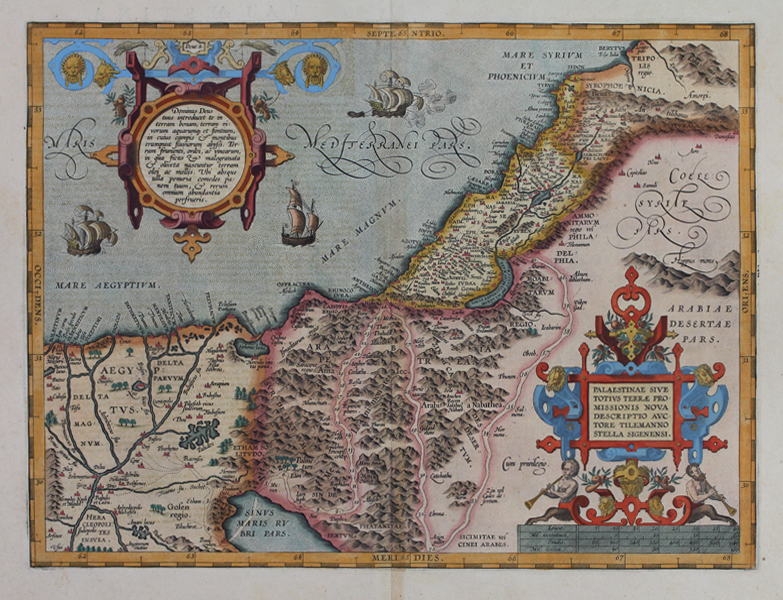
A map of the biblical 'Promised Land,' depicting the ancient coastal regions of Egypt, Arabia, Judea, and Syria from the 1603 Latin Parergon (Supplement) of Ortelius' famous Theatrum Orbis Terrarum. The various kingdoms are outlined and washed in hand colour, with principal cities and towns picked out in red. The Mediterranean features three sailing ships, and unusual historical features of each kingdom are depicted, including the Tomb of Pompey on the coast north of Pelusium and the tomb of Mary in the Wilderness of Zin. The path taken by the Jews in their exodus is also marked, beginning in the Egyptian city of Pi-Ramesses, crossing the Red Sea, and winding through the Arabian desert before reaching Judea. The map is embellished with two large decorative strap cartouches, one containing the title and a scale in miles, the other featuring a passage in Latin from Deuteronomy, promising the People of God a land rich in rivers, springs, and fields, where bread, honey, and all manner of fruits are produced in abundance. This is the third state of Ortelius' map of ancient Palestine. The earlier two feature a different number and arrangement of ships and sea monsters in the Mediterranean, as well as a compass rose where this example features the regional text for Coele Syria. The Parergon ('Supplement') was, as the title suggests, originally conceived of as a supplement to Ortelius' Theatrum. The work, a massive and intricately researched index of the classical world, was accompanied by a series of ancient world maps. Unlike the maps of the Theatrum, the majority of which were reductions of earlier maps, the maps of the Parergon were researched and drawn by Ortelius himself. The work was a huge commercial success, and the maps themselves set the standard for ancient world maps for the duration of the seventeenth century, being reproduced or reprinted by various publishers after Ortelius' final 1624 printing. His interest in the mapping of the ancient world is manifest. The maps of the Parergon are a veritable mine of textual commentary and classical philology, drawing upon Ptolemy, Strabo, Pliny, and many others. Interestingly, the project seems to have been a labour of love, rather than a mercantile venture. Ortelius himself was fascinated with the ancient world, and a formidable classical scholar in his own right. In addition to his work as a cartographer, he dealt in antiquities, visited and surveyed ancient sites across Europe, published a critical edition of Caesar's Gallic Wars in 1593, and assisted Welser in his studies of the famous Tabula Peutingeriana in 1598, producing an engraved copy of the map that can be found in later editions of the Parergon. Abraham Ortelius (1527 -1598) was a Flemish cartographer, cosmographer, geographer and publisher and a contemporary of Gerard Mercator, with whom he travelled through Italy and France. Although it is Mercator who first used the word "Atlas" as a name for a collection of maps, it is Ortelius who is remembered as the creator of the first modern atlas. Theatrum Orbis Terrarum was the first systematically collated set of maps by different map makers in a uniform format. Three Latin editions as well as a Dutch, French and German edition of Theatrum Orbis Terrarum were published by 1572 and a further 25 editions printed before Ortelius' death in 1598. Several more were subsequently printed until around 1612. Ortelius is said to have been the first person to pose the question of the continents once being a single land mass before separating into their current positions. Condition: Clean, crisp impression with full margins, presented in full wash colour. Central vertical fold as issued. Minor time toning to edges of sheet, not affecting map or plate. Latin text on verso. |
| Framing | unmounted |
| Price | £1,200.00 |
| Stock ID | 51216 |