
| Method | Copper engraved |
| Artist | Schenk, Pieter and Valk, Gerard after Jansson, Jan |
| Published | Amstelaedami. Apud Gerardum Valk et Petrum Schenk. [Amsterdam, c. 1715] |
| Dimensions | 380 x 485 mm |
| Notes |
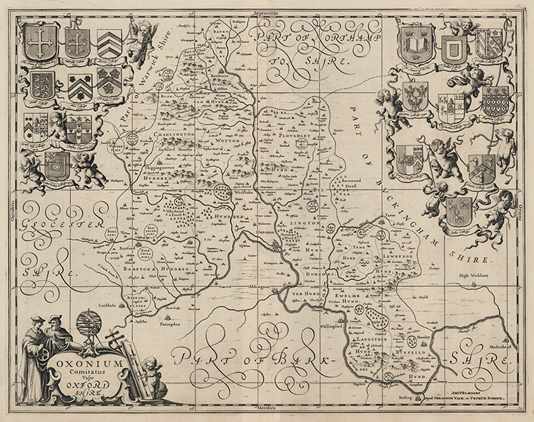
A large and decorative map of Oxfordshire, originally engraved for Jansson's Atlas Novus, here reissued with minor revisions by Schenk and Valk, who had acquired Jansson's plates at auction in 1694. The boundaries of the county hundreds are shown as dashed lines, hills, rivers, forests, and enclosures are shown pictorially, and the size of the various towns and villages of Oxfordshire is represented using icons of increasing magnitude. Oxford is depicted with a basic, but not representative, grid of streets. In the bottom left corner, two scholars and a cherub examine a set of cartographic tools that rest against the title cartouche. The map is further ornamented with a ribboned array of the crests of the colleges of the University of Oxford, held up by a host of cherubs. In addition to changing the imprint in the bottom right corner, Schenk and Valk have also added a graticule to Jansson's original plate. Although Schenk and Valk began issuing Jansson's plates shortly after purchasing them, both separately and in composite atlases, examples of the Oxfordshire map with their imprint are not usually seen until the publication of David Mortier's 1715 edition of the Atlas Anglois. Petrus Schenk (1660-1715) was born in Germany but moved to Amsterdam where he studied engraving with Gerard Valck. He had two shops where he sold maps and prints, one in Amsterdam and the other in Leipzig. This plate is from Schenk's early town atlas which depicted 100 cities on four continents. Gerald Valk (1652 -1726) was a Dutch publisher, globe maker, art seller and engraver. He trained under Abraham Bloteling, later becoming his assistant. The pair moved to London in 1672 where Valk worked with David Loggan and Christopher Browne. Gerard married Maria, Bloteling's daughter, and in 1675 their son, Leonard, was born. Johannes Janssonius (1588 - 1664) was a famed cartographer and print publisher. More commonly known as Jan Jansson, he was born in Arnhem where his father, Jan Janszoon the Elder, was a bookseller and publisher. In 1612 he married the daughter of the cartographer and publisher Jodocus Hondius, and then set up in business in Amsterdam as a book publisher. In 1616 he published his first maps of France and Italy and from then onwards, produced a very large number of maps which went some way to rival those of the Blaeu family, who held a virtual monopoly over the industry. From about 1630 to 1638 he was in partnership with his brother-in-law, Henricus Hondius, issuing further editions of the Mercator/Hondius atlases to which his name was added. On the death of Hondius he took over the business, expanding the atlas still further, until eventually he published an eleven volume Atlas Major on a scale similar to Johannes Blaeu's magnum opus. After Jansson's death, his heirs published a number of maps in the Atlas Contractus of 1666, and, later still, many of the plates of his British maps were acquired by Pieter Schenk and Gerard Valck, who published them again in 1694 as separate maps. Condition: Central vertical fold, as issued. Minor time toning on verso, otherwise blank. |
| Framing | unmounted |
| Price | £950.00 |
| Stock ID | 53436 |