
| Method | Copper engraved with original hand colour |
| Artist | Saxton, Christopher |
| Published | Ano. Dm. 1574. Christophorus Saxton descripsit. Johannes Rutlinger sculpsit. [London, c.1574] |
| Dimensions | 390 x 438 mm |
| Notes |
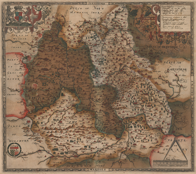
A first state printing of Christopher Saxton's seminal Elizabethan map of Oxfordshire, Berkshire, and Buckinghamshire, the earliest printed map of the counties here presented in early full wash colour. The villages, towns, and cities of each county are picked out in red, mountains, forests, enclosures, and waterways are showed pictorially, and adjoining parts of Surrey, Hampshire, Wiltshire, Gloucestershire, Warwickshire, Northamptonshire, Bedfordshire, Hertfordshire, and Middlesex are also shown. The map is further embellished by a set of ornate strapwork cartouches. The Royal crest, supported by a crowned lion and a gryphon, is enclosed in a strapwork box in the top left corner of the plate, while in the bottom left the arms of Saxton's patron, the Master of Requests Thomas Sackford, feature a motto more usually connected to the antiquarian Dugdale: Pestis Patriae Pegricies [Pigrities] - 'Indolence is the plague of the Nation.' A scale in miles is featured in the bottom right, and in the top right, the title cartouche is festooned with attributes of fecundity and prosperity, including fruits, flowers, bees, and even a lobster, while a bare-footed figure in classical dress standing by a smoking censer holds a knotted rope in an attempt to restrain a long-necked heraldic bird. A boxed text below the title gives a count of the towns, markets, and parishes in each county. Below this, a line of imperfectly erased text attributed the engraving of the plate to John Rutlinger. Christopher Saxton (c.1540 - c.1610) was a British estate surveyor and draughtsman, best known for his maps of English counties. Apprenticed to the cleric and cartographer John Rudd, Saxton developed the skills to become the man now known as 'the father of English cartography'. Under the patronage of Thomas Seckford, Saxton carried out an extensive topographical survey of England and Wales during the years 1573-1578. 34 county maps based on the surveys were engraved between 1574 and 1578 by Remy Hogenberg, Lenaert Terwoort, Cornelis de Hooghe, Augustine Ryther, Francis Scatte, and Nicholas Reynolds, forming the first atlas of England and Wales. The work was the basis for many later maps. The maps were issued by Saxton in untitled volumes from 1579, and subsequently reissued as The Shires of England and Wales, by William Web in 1645, by Philip Lea (with added maps) and in a French edition Atlas Anglois in 1693, by G Willdey in 1732, by T Jefferys in 1749, and finally as a wall map of England and Wales in 20 Sheets in c. 1770. Condition: Vertical centrefold as issued. Heavy verdigris from original colour. Toning from previous mount. Printer's creasing to centre top, upper left and lower left of sheet. repaired tear to top margin and small infill to bottom margin, not affecting printed area. Toning to sheet. Blank verso. Grapes watermark. Framed in a fine period style frame. |
| Framing | framed |
| Price | £6,000.00 |
| Stock ID | 52227 |