
| Method | Zincograph |
| Artist | [Anonymous] |
| Published | Heliozincographed and Published by the Director General at the Ordnance Survey Office, Southampton, 1899. |
| Dimensions | 640 x 958 mm |
| Notes |
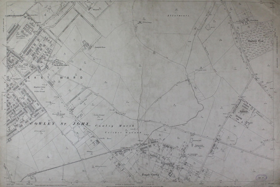
An Ordnance Survey map depicting parts of South East Oxford, covering Cowley Road from East Avenue to Milton Road and Marsh Road, depicting the Cowley Marsh with Cricket Grounds, which has now been redeveloped, as well as Temple Cowley, the old barracks which are located by what is now known as Barracks Lane, part of Hollow Way, the farmland now replaced by the Oxford Golf Club, and allotments some of which are now turned into housing. This map measures 25.5 x 38 inches, and uses a scale of 1:2500 inches. Inscription to bottom left: "Surveyed in 1872-75. Revised in 1898. Reprint 20/10." Ordnance Survey or "OS" is the national mapping agency of Great Britain. The agency provides the most recent and accurate geographic data of Great Britain to the government, businesses and individuals. It was officially founded in 1791, but has even earlier roots. The government first ordered the department of Defence to map the Scottish Highlands after a rebellion took place there in 1745. When the French Revolution started, a survey of the English south coast was ordered. These first surveys were meant to support strategic military planning. William Roy (1726 - 1790), an engineer who worked for the government on these first surveys, became convinced that accurate mapping of Great Britain in its entirety was needed. His vision greatly influenced the foundation of the Ordnance Survey. Between 1842 and 1893, the entire country was surveyed, and would be revised every twenty years. During the 1850's, there was a debate about the most efficient scale to use for ordnance maps, better known as the "Battle of the Scales". The scale of 25 inches to the mile became the standard scale used to map urban as well as rural areas from 1855 onwards, and is still used today. The less detailed scale of six inches to the mile were used only for some uncultivated rural areas, moorlands or mountainous areas. Ex. Col.: Oxford Corporation W.H. White, Engineer. City's Engineer Department. Condition: Laid to linen sheet with dark blue edge binding. Overall surface dirt built-up. Overall creasing Touched in black pen, adding new streets. |
| Framing | unmounted |
| Price | £175.00 |
| Stock ID | 46663 |