
| Method | Zincograph |
| Artist | [Anonymous] |
| Published | Zincographed under the Superintendence of Lt. Col. Parsons R.F.F.R.S. at the Ordnance Survey Office, Southampton. Lieut. General J. Cameron R.E. C.B. F.R.S. Director General. 1876 |
| Dimensions | 63 x 963 mm |
| Notes |
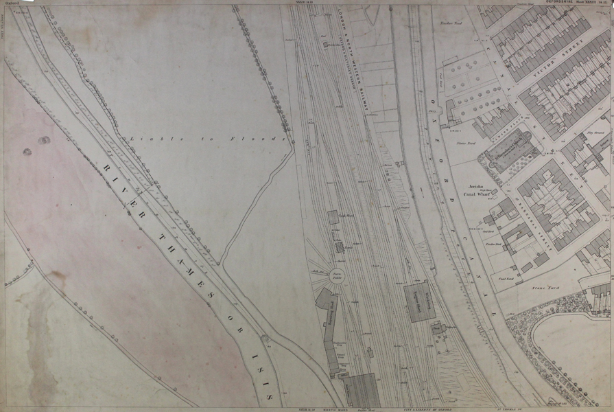
An Ordnance Survey map depicting part of North-West Oxford, centred on part of the railway, the Oxford Canal and the River Thames or Isis, covering Jericho from Canal Street with St Barnabas's Church and Victor Street. This map measures 24.8 x 38 inches, and uses a scale of 1:500 inches. Inscription to bottom centre: "Surveyed in 1876 by Capt. L.J.G. Ferrier. R.E. Levelled by Capt. W. Wynne R.E. (...) made on Buildings, Walls &c." Ordnance Survey or "OS" is the national mapping agency of Great Britain. The agency provides the most recent and accurate geographic data of Great Britain to the government, businesses and individuals. It was officially founded in 1791, but has even earlier roots. The government first ordered the department of Defence to map the Scottish Highlands after a rebellion took place there in 1745. When the French Revolution started, a survey of the English south coast was ordered. These first surveys were meant to support strategic military planning. William Roy (1726 - 1790), an engineer who worked for the government on these first surveys, became convinced that accurate mapping of Great Britain in its entirety was needed. His vision greatly influenced the foundation of the Ordnance Survey. Between 1842 and 1893, the entire country was surveyed, and would be revised every twenty years. During the 1850's, there was a debate about the most efficient scale to use for ordnance maps, better known as the "Battle of the Scales". The scale of 25 inches to the mile became the standard scale used to map urban as well as rural areas from 1855 onwards, and is still used today. The less detailed scale of six inches to the mile were used only for some uncultivated rural areas, moorlands or mountainous areas. Ex. Col.: Oxford City Council Condition: Laid to linen sheet with dark blue edge binding. Overall surface dirt built-up. Slight overall creasing, and tearing to edges of sheet and binding. The farmland next to the River Thames is touched with red hand colouring. |
| Framing | unmounted |
| Price | £175.00 |
| Stock ID | 46655 |