
| Method | Offset lithograph |
| Artist | Richardson, J. F. |
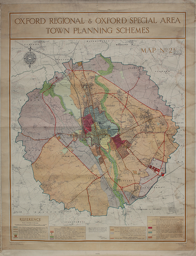
| Published | George Philip & Son, Ltd. 32 Fleet Street, E.C.4. Reproduced from the Ordnance Survey Map with the sanction of the Controller of H.M. Stationery Office. J.F. Richardson, M.A. City Engineer, Oxford [16th November, 1927] |
| Dimensions | 1480 x 1175 mm |
| Notes |
A very large city map of Oxford, printed by the cartographic publishers George Philip & Son for J.F. Richardson, the City Engineer, showing intended projects in the town planning and development of Oxford during the late 1920s. Of most significance is the draft proposal for the Oxford Ring Road, the first phase of which was constructed during the 1930s. The map itself is a facsimile of the Ordnance Survey, with colour lithographed overlays representing intended roads to be built or widened, and development of council housing and public infrastructure. The ring road is shown as a broad vermillion loop, encircling the city on almost the same route as the present ring road. Arterial roads such as Hollow Way and Marston Ferry Road are also earmarked, though the latter would not be completed for another 40 years after the plan was proposed. A series of colour-coded keys along the bottom margin of the map provide details about the city and its requirements, and the boundary of the City Council's jurisdiction and the borders of the parishes are also shown. Although the map was produced as a working planning document the inclusion of a printed price in the subscript below the map suggests that copies were also made publicly available at the time of issue. George Philip (1800–1882) was a cartographer and map publisher. Son of a staunchly Calvinist family, he became in 1819 assistant to the Liverpool bookseller William Grapel, and in 1834 started his own business in Liverpool producing maps and educational books. The business expanded rapidly. He used cartographers (such as John Bartholomew the elder, August Petermann, and William Hughes) to produce maps on copper plates. Philip then had these printed and hand-coloured by his women tinters. By the time he produced his county maps of 1862 he was using machine coloured maps produced on power-driven lithographic presses. He had one son, also George (1823–1902), who was admitted to the business in 1848 (and was the cause of the name change to George Philip & Son Ltd). The company continued to operate successfully until 1987 when it was sold to Reed International. Here it continued to trade as George Philip Ltd. In 1998, following a management buy-out of the Illustrated books division, Philip's became part of the Octopus Publishing Group. Hachette Livre acquired the group in 2001. Condition: Folds, creases, surface abrasion, staining, and splitting, commensurate with the map's use. Backed on linen, as issued. |
| Framing | unmounted |
| Price | £500.00 |
| Stock ID | 52679 |