
| Method | Chromolithograph |
| Artist | Lee, Kerry |
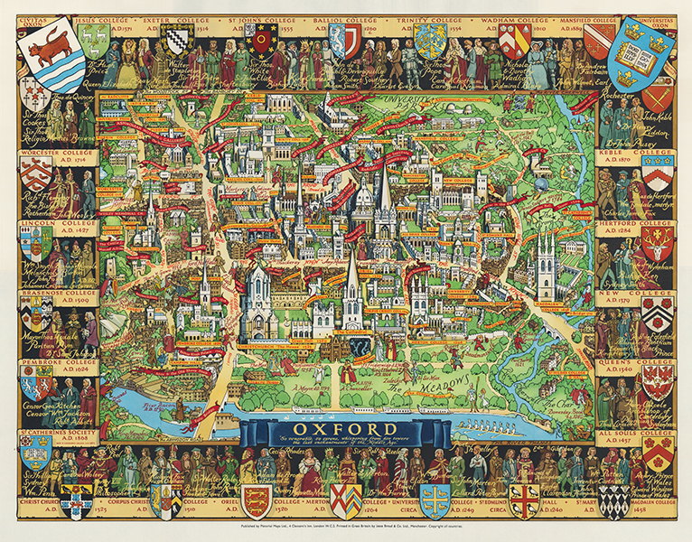
| Published | Published by Pictorial Maps Ltd, for the Travel Association of Great Britain and N. Ireland. Kerry Lee 1948 [c. 1962 impression] |
| Dimensions | 450 x 580 mm |
| Notes |
A decorative map depicting the centre of Oxford, with banderoles naming the colleges and interesting sites. The map is surrounded by 26 college emblems including portraits of the founders and famous alumni, and foundation dates. The map itself, stretching from St Giles in the North to Folly Bridge in the South, and from the Castle in the West to Magdalen Bridge and St Hildas in the East, overlays various figures and events from Oxford's history. Kerry Ernst Lee (1903-1988) was a British artist, born in Hackney, best known for a series of chromolithograph advertising posters issued by British railways, designed and used to help promote British tourism after the second world war. He attended Reading Schools of Arts and Science, the Slade, and the Sorbonne in Paris. Many of Kerry Lee's maps depict the artist sitting sketching in the corner, with his dog beside him. Condition: Original folds as issued. |
| Framing | mounted |
| Price | £575.00 |
| Stock ID | 53402 |