
| Method | Copper engraved with hand colour |
| Artist | Rothgiesser, Christian and Meyer, Johann |
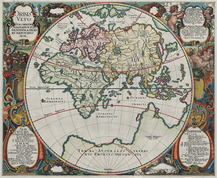
| Published | Casparus Danckwerth, D. Christian Rothgießer Husum sculpsit Ano 1651. [Husum, 1652] |
| Dimensions | 430 x 525 mm |
| Notes |
A rare mid-sixteenth century map of the Old World, divided according to the biblical Table of Nations, from Caspar Danckwerth's Newe Landesbeschreibung der zweij Hertzogthuemer Schleswig und Holstein. The map is presented in a single hemisphere, with Europe, Asia, and Africa labelled Japheth, Schem, and Cham after the sons of Noah. The map is based on the cartography of the Danish mathematician Johann Meyer, and was one of a suite of maps engraved to embellish the text of Danckwerth's atlas of his native Schleswig-Holstein. Notable anomalies are the depictions of the polar regions, with the arctic, following Mercator, shown as a group of four large islands around a central pole, and much of the region below the Tropic of Capricorn shown as a supercontinent labelled 'Terra Australis Veteribus Prorsus Incognita' - The Southern Land totally unknown to the Ancients. The borders surrounding the roundel containing the map are decorated with large and elaborate vignettes of the seasons, with emblems of plenty supported by putti. Four strapwork cartouches contain the title, a lengthy dedication, and two keys, containing the names of the sons of Noah and their descendants, with the lands they settled and the peoples they fathered listed alongside. Of particular interest is the inclusion of various European nations not mentioned in the original biblical texts. These, the Greeks, Thracians, Mysians, Dacians, Celts, Italians, Gauls, Illyrians, Germans, Danes, Swedes, and Norwegians, are listed as the children of Javan, Japheth's fourth son. The Romano-Jewish historian Josephus, writing in the first century AD, equated Javan with the mythic Ion, founding father of the Ionian Greeks, and by the era in which this map was made, it was a relatively common genealogical trope for authors to draw a direct lineage for most of the Christian peoples of Europe to Javan. Christian Rothgiesser (fl.1630-1659) was a German engraver active in Husum and Copenhagen. Johann Meyer (1606-1674) was a Danish mathematician, mapmaker, astronomer and geographer, active in his native Husum, and Copenhagen. An admirer and follower of the great Danish astronomer Tycho Brahe, Meyer was appointed Royal Mathematician to Christian IV, King of Denmark and Norway. As part of his work for the King, he surveyed Schleswig-Holstein, producing a suite of maps that were eventually engraved for inclusion in an atlas of the region by Caspar Danckwerth, Burgermeister of Husum. Danckwerth's text was criticised by King Christian for its perceived partisanship, particularly in its account of the dealings between the King and the Duke of Gottorf. The King's ire led to a rift between Meyer and Danckwerth, which was left unresolved by Danckwerth's death. The plates from the atlas were subsequently sold to Johannes Blaeu. Shirley 388 Condition: Central vertical fold, as issued. Blank on verso. |
| Framing | unmounted |
| Price | £1,200.00 |
| Stock ID | 53428 |