
| Method | Copper engraved with hand colour |
| Artist | Stoopendaal, Daniel after Visscher, Nicolas |
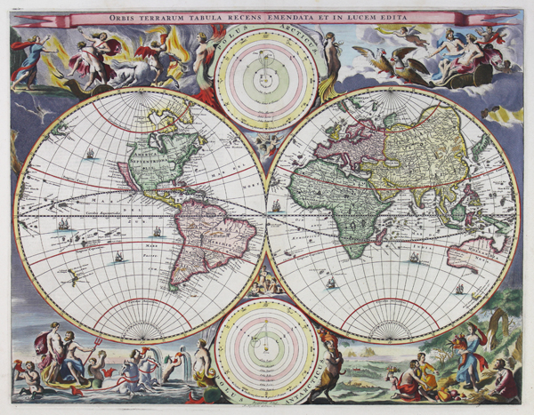
| Published | Stoopendaal Schul. A. Hogeboom Gelettert. [Hendrik and Jacob Keur, Dordrecht, c.1682] |
| Dimensions | 355 x 465 mm |
| Notes |
A striking late seventeenth century decorative Dutch world map in twin hemispheres, engraved by Stoopendaal for the Keur family's Dordrecht bible. Stylistically and cartographically, the map is a close copy of the slightly larger 1658 world map by Visscher and Berchem, itself derived from Blaeu's 1648 map. California is shown as a flat topped island, and a small islet called 'Anian' is shown above and to the west of a putative northern coast above California. The majority of the northern and eastern coastlines of Australia are mapped, though the eastern coast is absent, and the Cape York Peninsula is separated from New Guinea by a tiny break in coastline. Tasmania is partially mapped, as is a partial coastline of New Zealand in the western hemisphere. Antarctica is completely absent, and in the Arctic, only parts of Novaya Zemlya, Greenland, and Svalbard are shown. In the earlier Visscher map, a pair of smaller roundels between the hemispheres showed the Poles, though in Stoopendaal's bible maps, these are replaced by models of the orbits in our solar system, on heliocentric and geocentric patterns. Curiously the earlier titles, Polus Arcticus and Polus Antarticus, remain, flanked by sirens and silens, and supported by groups of cherubs. The title is emblazoned along the top in a ribbon, and the remaining space between the hemispheres and the border is occupied by a quartet of scenes from classical mythology representing the elements. In the top left, Hades carries off Persephone to the depths of the Underworld, Fire blazing around his chariot and its batwinged attendant. At top right, Zeus and Hera ride through the Aether on his chariot, pulled by a pair of eagles. The Water of the world's oceans hosts the sea god Poseidon, his consort Amphitrite, and his entourage of nereids and tritons. The final scene, at bottom right, celebrates the bounty of Earth, with Demeter presenting humankind with a cornucopia of fruit and grain in an Arcadian scene between forest and fields. Daniel Stoopendaal (1672-1726) was a Dutch engraver, mapmaker, and publisher, based in Amsterdam. The son of the printmaker Bastian Stoopendaal, he was active in Amsterdam, and is best known for producing world maps after Visscher, and plates of Dutch town houses and country estates for de Leth. Many of his maps were included in bibles published by the Keur family. The Visscher family produced maps and atlases in Amsterdam throughout the seventeenth and early eighteenth century. Established by Claes Janszoon Visscher (1587-1652), they mainly published atlases from plates purchased from Pieter van den Keere. The business was then continued by Claes' son Nicolas Visscher I (1618-1679) and his grandson Nicolas II. The Visschers published many revised editions of their 'Atlas Contractus' and 'Atlas Minor'. Upon the death of Nicholas II, his wife, Elizabeth, continued the business before selling it to Pieter Schenk. Shirley 513 Condition: Central vertical fold as issued. Old adhesive tape along top margin, not affecting map. Dutch text on verso. Framed in a handmade antique style gilt frame. |
| Framing | framed |
| Price | £3,750.00 |
| Stock ID | 50538 |