
| Method | Copper engraved with hand colour |
| Artist | Moll, Herman |
| Published | London: Printed for the Proprietor Carington Bowles, at his Map and Print Warehouse, No. 69, St Paul's Church Yard. MDCCLXXXIV [1784] |
| Dimensions | 157 x 226 mm |
| Notes |
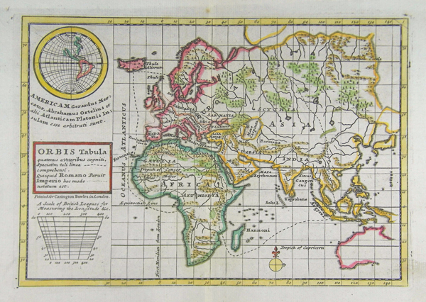
A map of the World, as known to the Ancients, from Bowles' Geographia Classica, or the Geography of the Ancients, as contained in the Greek and Latin Classics. The map depicts Europe, Asia, Africa, and most of the coast of Australia, as was known to Moll and his contemporaries. The continents are outlined in hand colour, as are forests, rivers, and mountain ranges. The extent of ancient knowledge of global geography is illustrated by a dashed line, and the regions within this are given their ancient names. The boundaries of the Roman empire are marked by a dotted line. The map draws on the standard range of works of classical geography, but is also heavily influenced by a number of ancient periploi, including those of the Euxine and Erythraean Seas. Above the simple box cartouche, is an inset globe-map of the Americas, following Mercator and Ortelius, that Moll equates with Plato's description of Atlantis. Bowles' Geographia Classica, or the Geography of the Ancients, as contained in the Greek and Latin Classics was undertaken by Herman Moll as a supplement to the many eighteenth century editions of Greek and Latin classics published by Carington Bowles and his contemporaries. Most editions contained a total of 32 maps in an arrangement similar to Ortelius' famous Parergon, depicting the kingdoms and provinces of the Greek and Roman world, elucidating particular texts such as 'Caesar's Gaul' or the 'Journeys of Aeneas,' and including a number of biblical maps. Unlike the Parergon, which was accompanied by Ortelius' copious notes and commentary, Moll's Geographia Classica contained no explanatory text, with the frontis instead explaining that the atlas was 'Principally designed for the Use of Schools, as being accomodated for the more easy and clear Understanding of the Ancient Authors.' The list as given by Moll included Homer, Herodotus, Justin, Virgil, Ovid, Florus, Nepos, Caesar, Livy, Lucan, and Plutarch. Herman Moll (c.1654-1732) was born in Germany and came to England in the 1670s. He worked as an independent cartographer and geographer, and traded as a map publisher and seller for two years, and then worked for other publishers. Moll established his own business and eventually dominated the early eighteenth century map trade. He produced many maps and atlases of England, Wales, Scotland and Ireland. His county maps were all boldly engraved in a heavy style. Moll was also an active member in academic and intellectual circles, being a close associate of Daniel Defoe, Robert Boyle, Robert Hooke, and, most importantly for his cartographic career, the pre-eminent English explorer of the era, William Dampier. Condition: Central vertical fold as issued. Minor time toning and foxing to margins of sheet, not affecting map. |
| Framing | mounted |
| Price | £200.00 |
| Stock ID | 41357 |