
| Method | Copper engraved with hand colour |
| Artist | Waghenaer, Lucas Janszoon |
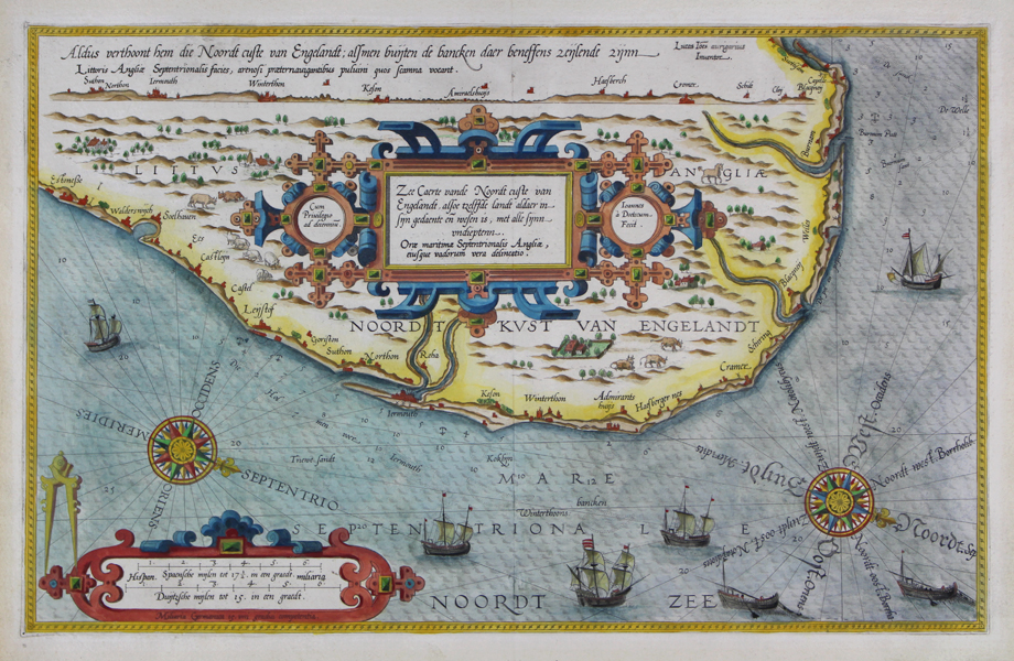
| Published | Lucas Ioannes aurigarius Inuentor. Ioannes a Doetecum Fecit. Cum Priuilegio ad decennium [1584 Latin edition] |
| Dimensions | 330 x 510 mm |
| Notes |
A rare and highly ornate sea chart of the East Anglian coast, from a Latin edition of Waghenaer's Spieghel der zeevaerdt ('Mirror of Navigation'). The map depicts the sea-coast from 'East Ness' in the south to 'Southsham' in the north, effectively Dunwich to Thornham, with labelled ports and coastal towns including Walberswick, Lowestoft, Yarmouth, Winterton, Cromer, Sheringham, Blakeney, and Welles. The map features numerous embellishments, including two large decorative compass roses in the bottom right and left, with the cardinal points in Latin and Dutch, and the names of the winds in latinized Greek. The waters of the English channel are populated with Dutch merchant ships, and fishing vessels dragging nets. The coasts of England are also heavily illustrated, with principal cities and towns depicted alongside vignettes of agriculture and industry, best exemplified by the cattle herds and flocks of sheep along the coast. A large strapwork cartouche at centre encloses the title in Latin and Dutch, and a smaller but still ornate example in the bottom left contains a scale in miles. Depth soundings and anchorages are given, as well as notes about sand banks and sinkholes. Along the top of the map, a topographic view of the coast is provided. The Latin verso text describes the various ports of the Norfolk coast, and the wind and sailing conditions applicable for each. Lucas Janszoon Waghenaer (1533-1606) was a Dutch cartographer, publisher, and naval officer. As a young man, Waghenaer served as a chief officer with the Dutch navy, and his experiences in a thirty year long career as a seafarer undoubtedly shaped his cartographic interests later in life. His first publication, the Spieghel der zeevaerdt ('Mirror of Navigation'), was published in 1584, gathering together a description and manual of sailing in western and northern Europe with a collection of maps, the cartography for which he seems to have carrier out almost entirely from his own navigational experience. His partnership with the engraver Johan van Doetinchem proved highly fruitful, and the atlas was reprinted numerous times in English, German, French, and Latin. van Doetinchem's imaginative and ebullient ornamentation set the Spieghel der zeevaerdt's maps apart, with each chart embellished with ornate compass roses, decorative cartouches, ships, sea monsters, and vignettes of towns, livestock, farming, and local colour. The Spieghel der zeevaerdt was followed in 1592 by the Thresoor der Zeevaert ('Treasure of Navigation') and the Enchuyser zeecaertboeck ('Enkhuizen Sea-Chart Book') in 1598. Waghenaer's contribution to navigation was such that collections and atlases of sea-charts became known in English as 'Waggoners,' the anglicised version of the author's surname. Condition: Excellent crisp impression with full margins. Central vertical fold as issued. Minor repaired tears to top and bottom of central fold, and to left margin. |
| Framing | unmounted |
| Price | £1,600.00 |
| Stock ID | 49038 |