
| Method | Copper engraved with early hand colour |
| Artist | Zatta, Antonio |
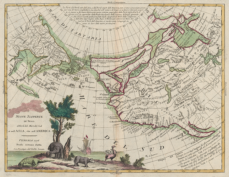
| Published | Venezia 1776. Presso Antonio Zatta, Con Privilegio dell'Ecc.mo Senato [Venice, 1776] |
| Dimensions | 310 x 405 mm |
| Notes |
A late eighteenth century map of the northern Pacific Ocean, and one of the most sought after speculative maps of the famous Northwest Passage, from Zatta's rare but important Italian world atlas, the Atlante Novissimo. The map shows the most northeasterly parts of Asia, as well as most of the North American continent. The northwestern coast of America is full of erroneous but interesting details drawn from numerous source traditions for the region, chief amongst them the voyages of the likely-fictitious navigator, the Spanish admiral Bartolomeo de Fonte, said to have sailed up the coast in a 1640 expedition which discovered and traversed a series of great lakes north of Quivira. Rumours of a northwest passage had persisted among the European nations since at least as early as the 1560s, when the 'Straights of Anian' began to feature regularly on maps of the Pacific coast of the American continent, and continued to be periodically revisited and reinterpreted by numerous mapmakers until Cook's voyage of 1778, just a few years after the publication of this map, permanently dispelled serious belief in the passage. In Zatta's map, Anian is mapped alongside 'Fou-Sang,' a country described by the fifth century Monk Huishen as far to the west of China, which gave rise to a belief that the Chinese were the first 'old-worlders' to reach the Americas, establishing a colony of the same name on the Pacific Northwest coast. The region north of Anian is presented as a collection of very large islands, separated by great lakes which span the entire continent, connecting to Hudson Bay and Baffin's Bay in the top right corner of the map. Below this, the real great lakes, Huron, Michigan, and Superior are mapped, as is Salt Lake in the centre of the continent, and California is shown correctly as a peninsula. In the bottom left of the map, the title is flanked by a very large vignette of 'exotic' animals, including a crocodile, an elephant, a rhino, and an ostrich, as well as a sailing ship often identified as HMS Endeavour, the famous ship of Cook's first voyage. Antonio Zatta (fl.1757-1797) was an Italian geographer, historian, printer, and publisher, active in Venice in the second half of the eighteenth century. Few details are known about his life, but his output was prolific. Chief amongst his publications was his Atlante Novissimo, a four volume atlas of the world. As Zatta himself attested, the atlas contained a suite of the most up to date maps of the world yet produced in Italy, including some of the earliest adoptions of the discoveries of Cook in the mapping of Australia, New Zealand, and the south Pacific Condition: Central vertical fold, as issued. Time toning to central fold, and edges of sheet. Blank on verso. |
| Framing | unmounted |
| Price | £775.00 |
| Stock ID | 53485 |