
| Method | Copper engraved |
| Artist | Hondius, Jodocus |
| Published | [Tot Amsterdam, Ghedruckt by Iudocum Hondium, woonende inde Calver-Straet, inden Wackeren Hont. Anno 1614. Met Privilegie.] |
| Dimensions | 80 x 120 mm |
| Notes |
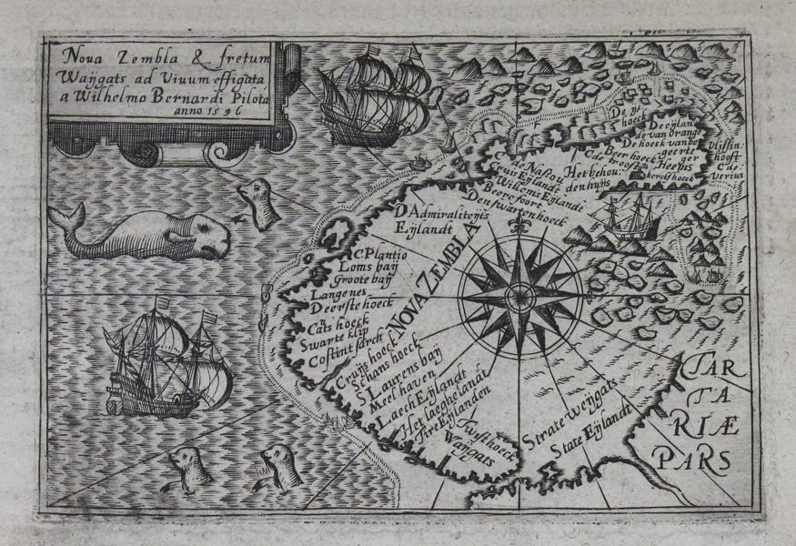
A miniature map of Nova Zembla, modern day Novaya Zemlya in the Russian polar, engraved for the 'Historische beschrijvinghe der seer wijt beroemde coop-stadt Amsterdam' by Pontanus. The region is depicted with particular reference to the journey of Willem Bernardt in 1596. The path of the journey is marked as a pair of dashed lines, and the western coast of Nova Zembla is particularly well charted, unlike the east coast which is largely blank. The map is embellished by a large compass rose, three sailing ships, a whale, and a trio of seals, as well as the numerous icebergs and floes encountered on the journey. On the verso, a large copper engraved scene depicts the Dutchmen trading from their ship with a smaller Muscovite vessel. The Russian merchants can be identified by their distinctive fur-lined caps. 'Historische beschrijvinghe der seer wijt beroemde coop-stadt Amsterdam' (Historical description of the famous trading city Amsterdam) by Johannes Isaac Pontanus was first published in Latin ('Rerum et urbis Amstelodamensium historia') by Jodocus Hondius in Amsterdam in 1611. Three years later, in 1614, Jodocus Hondius had the book translated by Petrus Montanus into Middle-Dutch and published it again. The book was put on the Index because of its hostility towards Roman Catholics. The book was essentially a cumulative history of all Dutch knowledge of the world, through the efforts of the Dutch East Indies Company (VOC) and their various commercial and exploratory enterprises. This print is from a rare Dutch edition of the publication. Johannes Isacius Pontanus (1571–1639) was born when his parents had fled Haarlem to go to Denmark. He later adopted his academic name Pontanus ("of the sea") because he would have been born at sea, when his parents were still on their way to Denmark. Shortly after his birth, his father Isaach Pietersz. was appointed by the Danish King Frederik II to return to the Netherlands and work as an agent. The family settled in Amsterdam, were Pontanus would spent most of his childhood. He would go on to study in Utrecht and Leiden and was promoted to doctor of medicine in Basel in 1601. He traveled often to Denmark and also visited Germany, Italy and France. He became a professor at the Gymnasium Illustre in Gelderland in 1604 and was appointed as the Royal Danish historian by King Christian IV. He wrote a history of Amsterdam in 1611, of Denmark from 1618 to 1631 and of the States of Gelderland in 1639 as well as several shorter works of history. He was married to Anneken van Heede with whom he had nine children. Jodocus Hondius (14th October 1563 - 12th February 1612) was a Dutch Flemish cartographer, engraver, and publisher. Hondius is most famous for reviving the primacy of the work of Gerard Mercator, through the publication of his Atlas, and the smaller Atlas Minor, in the early seventeenth century, at a time when cartography was largely dominated by Ortelius' Theatrum Orbis Terrarum. The Mercator-Hondius Atlas was composed of maps pulled from plates Hondius had purchased from Mercator's grandson, as well as thirty-six new plates Hondius commissioned, and in many cases engraved, himself. He is also believed to have been the chief engraver of the plates for John Speed's Theatre of the Empire of Great Britaine. Following his death, he was succeeded by his sons, Jodocus the Younger and Henricus, as well as his son in law Jan Jansson. Condition: Strong, dark impressions on full sheet. Dutch text above and below plate, and on verso. |
| Framing | unmounted |
| Price | £100.00 |
| Stock ID | 42975 |