
| Method | Copper engraved |
| Artist | Williams, William |
| Published | [Oxford, c. 1732-1733] |
| Dimensions | 450 x 533 mm |
| Notes |
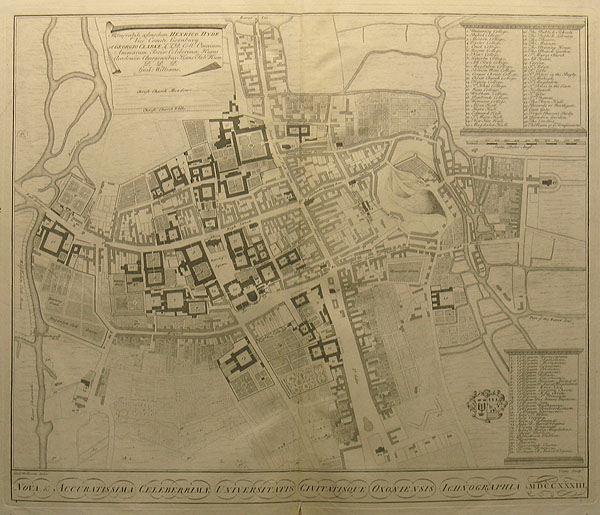
The last of the south-at-top orientated maps of the city of Oxford, providing a clear and detail depiction of the city's growth in the 18th century. From William Williams' 'Oxonia Depicta sive Collegiorum et Aularum in Inclyta Academia Oxoniensi Ichnographica & Scenographica Delineatio LXV Tabulis Aeneis expressa A Guilielmo Williams Cui accedit Uniuscujusque Collegij Aulaeque Notitia'. William Williams (fl. 1720-4), often using the Latinate version of his name 'Guilielmus Williams', was an architectural draughtsman, and this is reflected in the formality of many of the engravings in his 'Oxonia Depicta'. The contents of the work are similar to those in Loggan's 'Oxonia Illustrata' published over 50 years earlier, commencing with a double-prospect of the city of Oxford each containing a numbered key, and a plan of the city after Agas' plan of 1588. There is a double prospect of the interior of the Bodleian Library after Loggan and a number of architectural plans of the colleges. More importantly the work includes 10 fine large engravings of the colleges of Magdalen, Corpus, Wadham, St. Johns, Queens, New, Oriel, Trinity, Pembroke, and Brasenose, showing how they were at the beginning of the 18th Century. They are in fact, in many instances, the only visual records of the buildings at this time in their history. Condition: Small worm holes to the bottom margin, one just inside of plate, minor tear to the lower margin close to centre fold just affecting map border. Vertical printers crease close to the centre fold to the lower half of map. Diagonal crease to the left hand margin. |
| Framing | framed |
| Price | £1,200.00 |
| Stock ID | 26878 |