
| Method | Copper engraved with hand colour |
| Artist | Chatelain, Henri Abraham |
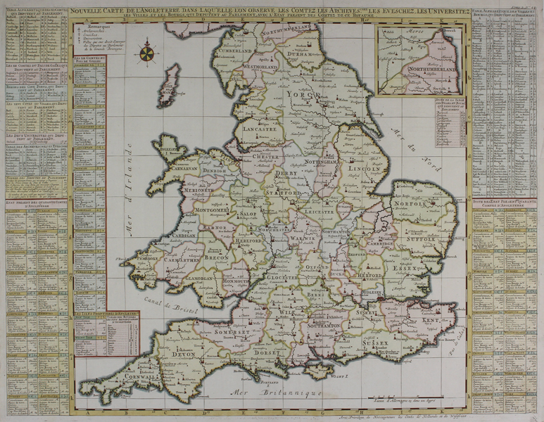
| Published | Avec Privilege de Nosseigneurs les Etats de Hollande et de Westfrize [Amsterdam, c.1719] |
| Dimensions | 472 x 635 mm |
| Notes |
A detailed and beautiful map of England and Wales, from Chatelain's Atlas Historique. The historic counties are shaded in full wash colour, in the tri-colour pastel palette typical of eighteenth century French maps. County towns and cities are picked out in red, and the parts of Northumberland that extend beyond the border of the plate are included in an inset boxed map in the top right. Like the majority of Chatelain's plates, the map is flanked by large columns of lists and explanatory text. Full title: Nouvelle Carte de l'Angleterre dans l'Aquelle l'on Observe les Comtez, les Archeves. chez les Eveschez, les Universitez, les Villes, et les Bourgs, qui Deputent au Parlement, avec l'Etat present des Comtez de ce Royaume. Henri Abraham Chatelain (1684-1743) was a Dutch cartographer of Parisian origins, who lived and worked in St. Martins, London (c. 1710), The Hague (c. 1721), and Amsterdam (c. 1728). He is best known for the seminal seven volume Atlas Historique (published in Amsterdam, 1705 - 20) which combined maps and topography with scholarly studies of geography, history, ethnology, heraldry, and cosmography. The Atlas was a family undertaking, managed by Henri and his father, Zacharie, and going through a number of editions. The majority of the maps for the work were engraved by Henri after charts by De L'Isle. Condition: Vertical and horizontal folds as issued. Minor staining and repaired tears to edges of sheet, not affecting map. Blank on verso. |
| Framing | unmounted |
| Price | £275.00 |
| Stock ID | 48481 |