
| Method | Copper engraved with hand colour |
| Artist | Mercator, Gerard and Hondius, Jodocus |
| Published | [Amsterdam, c.1620] |
| Dimensions | 350 x 465 |
| Notes |
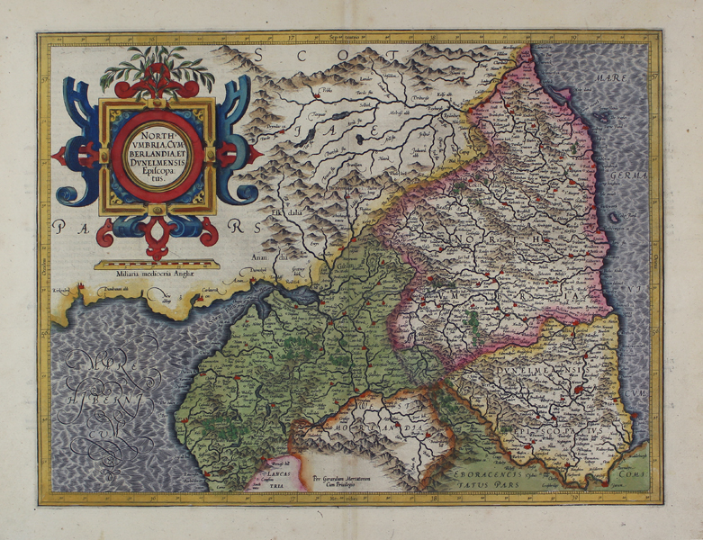
A beautiful early seventeenth century map of the northern counties of England, from a Latin edition of the Mercator-Hondius Atlas Major, essentially a reprint of Mercator's earlier Atlas sive Cosmographiae further expanded with new plates engraved by Hondius. The map shows Cumbria, Northumberland, Westmorland, Durham, and adjacent parts of Lancashire, Yorkshire, and Scotland. County boundaries are outlined in hand colour, and Mercator's heavily hatchured seas are washed in blue. Forests, rivers, lakes, and hills are depicted pictorially, and principal cities and towns are picked out in red. Hadrian's wall, depicted as a hatched line, is here labelled as the 'Murus Picticus,' the Picts' Wall. The map is further embellished with a large and ornate strapwork cartouche in the top left corner, above a scale in English miles. Gerard Mercator (1512 - 1594) originally a student of philosophy was one of the most renowned cosmographers and geographers of the 16th century, as well as an accomplished scientific instrument maker. He is most famous for introducing Mercators Projection, a system which allowed navigators to plot the same constant compass bearing on a flat map. His first maps were published in 1537 (Palestine), and 1538 (a map of the world), although his main occupation at this time was globe-making. He later moved to Duisburg, in Germany, where he produced his outstanding wall maps of Europe and of Britain. In 1569 he published his masterpiece, the twenty-one-sheet map of the world, constructed on Mercator's projection. His Atlas, sive Cosmographicae Meditationes de Fabrica Mundi, was completed by his son Rumold and published in 1595. After Rumold's death in 1599, the plates for the atlas were published by Gerard Jr. Following his death in 1604, the printing stock was bought at auction by Jodocus Hondius, and re-issued well into the seventeenth century. Jodocus Hondius (14th October 1563 - 12th February 1612) was a Dutch Flemish cartographer, engraver, and publisher. Hondius is most famous for reviving the primacy of the work of Gerard Mercator, through the publication of his Atlas, and the smaller Atlas Minor, in the early seventeenth century, at a time when cartography was largely dominated by Ortelius' Theatrum Orbis Terrarum. The Mercator-Hondius Atlas was composed of maps pulled from plates Hondius had purchased from Mercator's grandson, as well as thirty-six new plates Hondius commissioned, and in many cases engraved, himself. He is also believed to have been the chief engraver of the plates for John Speed's Theatre of the Empire of Great Britaine. Following his death, he was succeeded by his sons, Jodocus the Younger and Henricus, as well as his son in law Jan Jansson. Condition: Central vertical fold as issued. Repaired tear to bottom margin, not affecting map or plate. Minor time toning to central fold. Latin text on verso. |
| Framing | unmounted |
| Price | £575.00 |
| Stock ID | 45461 |