
| Method | Copper engraved with hand colour |
| Artist | Jansson, Jan |
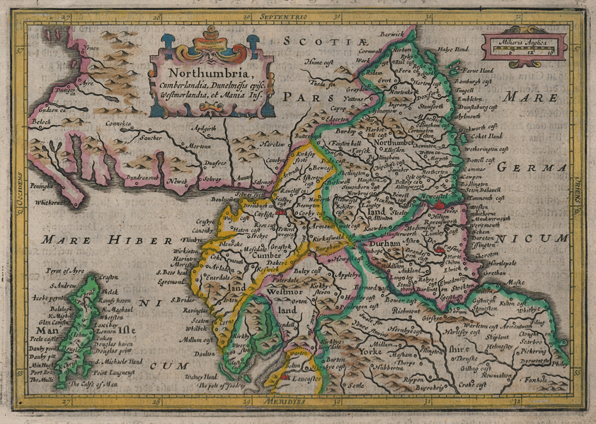
| Published | [Jan Jansson, Amsterdam, c.1640] |
| Dimensions | 138 x 196 mm |
| Notes |
A decorative miniature map of the North of England, issued by Jansson to replace an earlier plate of the same title by Hondius, from a Jansson printing of a German edition of the Mercator-Hondius Atlas Minor. The county borders of Northumberland, Cumbria, Westmorland, County Durham, and adjoining parts of Lancashire, Yorkshire, Scotland, and the Isle of Man are outlined in hand colour and principal towns are picked out in red. The title is enclosed in a baroque cartouche in top left, and in the top right corner is a scale of English miles. Gerard Mercator (1512 - 1594) originally a student of philosophy was one of the most renowned cosmographers and geographers of the 16th century, as well as an accomplished scientific instrument maker. He is most famous for introducing Mercators Projection, a system which allowed navigators to plot the same constant compass bearing on a flat map. His first maps were published in 1537 (Palestine), and 1538 (a map of the world), although his main occupation at this time was globe-making. He later moved to Duisburg, in Germany, where he produced his outstanding wall maps of Europe and of Britain. In 1569 he published his masterpiece, the twenty-one-sheet map of the world, constructed on Mercator's projection. His Atlas, sive Cosmographicae Meditationes de Fabrica Mundi, was completed by his son Rumold and published in 1595. After Rumold's death in 1599, the plates for the atlas were published by Gerard Jr. Following his death in 1604, the printing stock was bought at auction by Jodocus Hondius, and re-issued well into the seventeenth century. Jodocus Hondius (14th October 1563 - 12th February 1612) was a Dutch Flemish cartographer, engraver, and publisher. Hondius is most famous for reviving the primacy of the work of Gerard Mercator, through the publication of his Atlas, and the smaller Atlas Minor, in the early seventeenth century, at a time when cartography was largely dominated by Ortelius' Theatrum Orbis Terrarum. The Mercator-Hondius Atlas was composed of maps pulled from plates Hondius had purchased from Mercator's grandson, as well as thirty-six new plates Hondius commissioned, and in many cases engraved, himself. He is also believed to have been the chief engraver of the plates for John Speed's Theatre of the Empire of Great Britaine. Following his death, he was succeeded by his sons, Jodocus the Younger and Henricus, as well as his son in law Jan Jansson. Johannes Janssonius (1588-1664) was a famed cartographer and print publisher. More commonly known as Jan Jansson, he was born in Arnhem where his father, Jan Janszoon the Elder, was a bookseller and publisher. In 1612 he married the daughter of the cartographer and publisher Jodocus Hondius, and then set up in business in Amsterdam as a book publisher. In 1616 he published his first maps of France and Italy and from then onwards, produced a very large number of maps which went some way to rival those of the Blaeu family, who held a virtual monopoly over the industry. From about 1630 to 1638 he was in partnership with his brother-in-law, Henricus Hondius, issuing further editions of the Mercator/Hondius atlases to which his name was added. On the death of Hondius he took over the business, expanding the atlas still further, until eventually he published an eleven volume Atlas Major on a scale similar to Johannes Blaeu's magnum opus. After Jansson's death, his heirs published a number of maps in the Atlas Contractus of 1666, and, later still, many of the plates of his British maps were acquired by Pieter Schenk and Gerard Valck, who published them again in 1683 as separate maps. Condition: Minor time toning and dirt staining to edges of sheet. Tear to top left corner of sheet. German letterpress text above plate, and on verso. |
| Framing | mounted |
| Price | £225.00 |
| Stock ID | 52487 |