
| Method | Heliozincograph |
| Artist | [Anonymous] |
| Published | [Heliozincographed and Published by the Director General at the Ordnance Survey Office, Southampton, 1899.] |
| Dimensions | 1750 x 1935 mm |
| Notes |
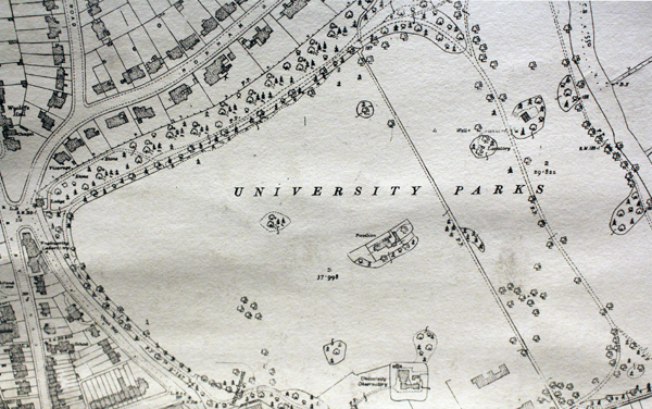
A large scale map of North Oxford on a scale of 1:2500 inches. The map centres on Summertown and map features the area from Cutteslowe, Wolvercote and Port Meadow through Summertown as far as St. Giles and from Binsey in the west to Marston in the east. Printed on eight sheets and laid to linen, with original wooden rollers. Ordnance Survey or "OS" is the national mapping agency of Great Britain. The agency provides the most recent and accurate geographic data of Great Britain to the government, businesses and individuals. It was officially founded in 1791, but has even earlier roots. The government first ordered the department of Defence to map the Scottish Highlands after a rebellion took place there in 1745. When the French Revolution started, a survey of the English south coast was ordered. These first surveys were meant to support strategic military planning. William Roy (1726 - 1790), an engineer who worked for the government on these first surveys, became convinced that accurate mapping of Great Britain in its entirety was needed. His vision greatly influenced the foundation of the Ordnance Survey. Between 1842 and 1893, the entire country was surveyed, and would be revised every twenty years. During the 1850's, there was a debate about the most efficient scale to use for ordnance maps, better known as the "Battle of the Scales". The scale of 25 inches to the mile became the standard scale used to map urban as well as rural areas from 1855 onwards, and is still used today. The less detailed scale of six inches to the mile were used only for some uncultivated rural areas, moorlands or mountainous areas. Ex. Col.: Oxford City Council Condition: Some over all surface dirt especially toward the top of the map. The printed Ordnance Survey information has been trimmed off each sheet before the map was laid to linen. Please Note: The photograph above is a detail of the whole. The map is too large for us to photograph in full. |
| Framing | unmounted |
| Price | £400.00 |
| Stock ID | 46665 |