
| Method | Copper engraved with early hand colour |
| Artist | Georg Braun and Frans Hogenberg |
| Published | [Cologne, c.1581] |
| Dimensions | 295 x 420 mm |
| Notes |
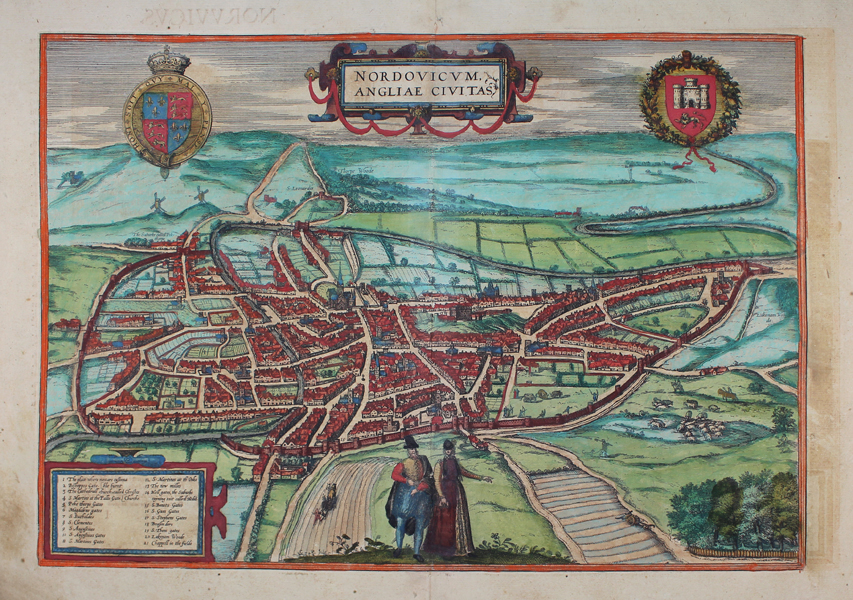
A striking birds-eye plan of the city of Norwich in the late sixteenth century, ornamented in early hand colour, from the third volume of Braun and Hogenberg's Civitates Orbis Terrarum. The city is viewed from the west, with the Cathedral and Castle at centre. The medieval walls are clearly depicted, and the river Wensum winds across the fields in the distance. In the foreground, a man and woman in noble dress illustrate the city's importance during the Late Medieval and Tudor eras. The map is further embellished by a series of cartouches, containing the title, key, and the Royal and City crests. Between 1572 and 1617 Georg Braun (1541-1622) and Frans Hogenberg (1535-1590) published six volumes of their Civitates Orbis Terrarum, containing over 500 prospects, views, and maps of mostly European cities, envisioned as a companion to Ortelius' atlas Theatrum Orbis Terrarum. Braun was the editor of the series, with Hogenberg as principle engraver. They relied mainly on existing cartography, but also on drawings made by the Antwerp artist Joris Hoefnagel (1542-1600), who had travelled through most of Western Europe. After Joris Hoefnagel's death his son Jakob continued the work for the Civitates. Condition: Central vertical fold as issued. Tear to centre of top margin, not affecting map or plate. Some offsetting and time toning to margins, not affecting map. Latin text on verso. |
| Framing | mounted |
| Price | £650.00 |
| Stock ID | 45438 |