
| Method | Copper engraving with hand colouring |
| Artist | after Henry Popple |
| Published | [Covens & Mortier, Amsterdam, c.1740] |
| Dimensions | Image 122 x 266 mm, Sheet 168 x 298 mm |
| Notes |
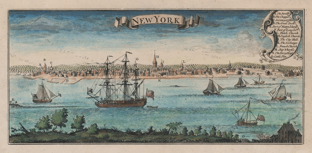
A very rare eighteenth century prospect of New York, a very close copy of the inset prospect engraved by William Henry Toms for Henry Popple's celebrated 20 sheet map of North America, which was first published in 1733. This particular example was reengraved for the Amsterdam publishing house of Covens & Mortier, who printed their own edtions of Popple's map from around 1737 onwards. This print would once have appeared on a single plate with the other three prospects from Popple's map, which depicted Quebec, Mexico City, and the Niagara Falls. The scene shows pre-Revolutionary War New York from Brooklyn, looking across the East River. The Fort, now the Battery Park can be seen at the far left, and the view stretches along the southern waterfront of Manhattan Island as far as the ship wharves, roughly where the Brooklyn Bridge now stands. At centre, the English Church and the Town Hall can be seen, the latter of which became the original Federal Hall in 1789 after the ratification of the Constitution following the Revolutionary War. On the waters of the East River, various sailing vessels can be seen, the majority of which are small merchant vessels, though a large warship flying the red ensign is prominent at centre. Henry Popple (fl.1722-1743) was a British colonial administrator, cartographer, and later Cashier to Queen Caroline, best known for his monumental and historically important 20-sheet map of North America. Popple, like other members of his family, worked for the Board of Trade and Plantations, giving him a personal familiarity with the changeable positions of the colonial powers in North America. By 1730, at which time Popple was working as a financial agent in the West Indies, the Lords Commissioner of Trade and Plantations were in need of detailed charts of the continent, largely to counter the superior mapping of Delisle relied upon by the French, whose aspirations in Canada and Louisiana were a source of growing concern to the English colonies. Popple's map, engraved by Toms, was finally issued in 1733. Although colour coded to represent the colonial holdings of Britain, France, Spain, and the Dutch, as well as Indian territories, the map initially failed commercially, and was never officially endorsed by the Board of Trade and Plantations. By the outbreak of the War of Jenkin's Ear though, the map had become a prominent symbol amongst the colonial elite, with Benjamin Franklin and George Washington reputed to have owned and displayed copies. Toms and Samuel Harding continued to market the map after Popple's death in 1743, until the rights were sold to Willdey in 1746, who reissued it until 1750. Pieter Mortier (1661-1711) was an 18th-century mapmaker and engraver from the Northern Netherlands. Mortier was born in Leiden. According to Houbraken, David van der Plas worked with him on etchings for Bybelsche Tafereelen (Bible stories), published in Amsterdam in 1700. He was the father of Cornelis Mortier (1699-1783), who in partnership with Johannes Covens I (1697-1774) began the map publishing company Covens & Mortier (1721-1866). He travelled to Paris in 1681-1685 and won the privilege in 1690 of publishing maps and atlases by French publishers in Amsterdam. He used this privilege to win a similar set of privileges for printing an "illustrated print bible" in 1700. He died in Amsterdam. Condition: Trimmed within platemark at left and bottom. Strong clean impression with early hand colouring. Light time toning to margins from old mount. Two ink stains and foxing to verso, otherwise blank. |
| Framing | mounted |
| Price | £1,600.00 |
| Stock ID | 51904 |