
| Method | Copper engraved with hand colour |
| Artist | Speed, John |
| Published | Described by Iohn Norden, Augmented by I. Speed. Solde by Thomas Baßett in Fleet Street, and Richard Chiswell in St Pauls Churchyard [1676] |
| Dimensions | 385 x 510 mm |
| Notes |
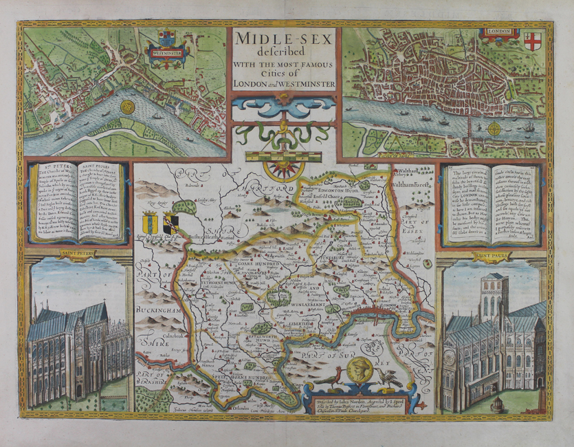
John Speed's decorative map of the county of Middlesex from the 1676 Bassett and Chiswell printing of the celebrated Theatre of the Empire of Great Britaine. Speed's map is based on the survey of the county undertaken by John Norden for the Speculum Britanniae. The county is divided into the Hundreds, and the borders to left and right feature matched pairs of city plans and vignettes, showing at left Westminster and St Peters, and at right the City of London and St Pauls. Between the vignettes, a pair of open books describe the history of St Peters and St Pauls churches, that they were each originally Roman temples to Apollo and Diana respectively, as well as a note about the beauty and scale of the buildings, parks, and streets of London. English text on verso describing the county, accompanied by a list of Middlesex's hundreds, and an alphabetical list of place names. John Speed (1552-1629) is the most famous of all English cartographers primarily as a result of The Theatre of the Empire of Great Britaine, the first atlas of the British Isles. The maps from this atlas are the best known and most sought-after of all county maps. The maps were derived mainly from the earlier prototypes of Christopher Saxton and John Norden but with notable improvements including parish "Hundreds" and county boundaries, town plans and embellishments such as the coats of arms of local Earls, Dukes, and the Royal Household. The maps are famed for their borders consisting of local inhabitants in national costume and panoramic vignette views of major cities and towns. An added feature is that regular atlas copies have English text printed on the reverse, giving a charming description of life in the early seventeenth century of the region. The overall effect produced very decorative, attractive and informative maps. For the publication of his prestigious atlas, Speed turned to the most successful London print-sellers of the day, John Sudbury and George Humble. William Camden introduced the leading Flemish engraver, Jodocus Hondius Sr. to John Speed in 1607 because first choice engraver William Rogers had died a few years earlier. Work commenced with the printed proofs being sent back and forth between London and Amsterdam for correction and was finally sent to London in 1611 for publication. The work was an immediate success, with the maps themselves being printed for the next 150 years. Speed was born in 1552 at Farndon, Cheshire. Like his father before him he was a tailor by trade, but around 1582 he moved to London. During his spare time Speed pursued his interests of history and cartography and in 1595 his first map of Canaan was published in the "Biblical Times". This raised his profile and he soon came to the attention of poet and dramatist Sir Fulke Greville a prominent figure in the court of Queen Elizabeth. Greville as Treasurer of the Royal Navy gave Speed an appointment in the Customs Service giving him a steady income and time to pursue cartography. Through his work he became a member of such learned societies as the Society of Antiquaries and associated with the likes of William Camden, Robert Cotton, and William Lambarde. He died in 1629 at the age of seventy-seven. Condition: Central vertical fold as issued. Minor repaired tears to bottom of central fold and bottom right corner of sheet, not affecting map. Inscription on recto for Bassett and Chiswell, though woodcut initial on verso is Skelton type E, for 1665 Roger Rea imprint. |
| Framing | framed |
| Price | £1,500.00 |
| Stock ID | 50948 |