
| Method | Woodcut with hand colour |
| Artist | Münster, Sebastian |
| Published | [Basel, c.1550] |
| Dimensions | 120 x 80 mm |
| Notes |
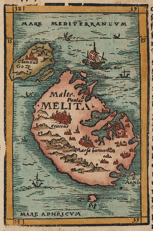
A mid-sixteenth century woodcut map of Malta and Gozo, from a German edition of Munster's celebrated Cosmographia, and one of the earliest printed maps of the islands. The map was made before the construction of Valetta, so the 'city' of Malta is Mdina, though Fort St Elmo is shown on the Sciberras peninsula with a large flag denoting its connection with the Knights of St John. The main centres of the island are illustrated as churches and town walls, picked out in red, and hills and mountains are shown pictorially. In the seas around the islands, numerous ships and shipwrecks are shown, the latter a nod to the famous shipwreck of St Paul during his travels. The map is further embellished in full hand colour. Sebastian Münster (20th January 1488 - 26th May 1552) was a German cartographer, cosmographer, and theologian. A gifted scholar of Hebraic, Münster originally joined the Franciscans, but left the order in favour of the Lutheran Church. He was appointed to the University of Basel in 1529, and published a number of works in Latin, Greek, and Hebrew. His most celebrated works are his Latin edition of Ptolemy's Geographia in 1540, and the Cosmographia in 1544. The Cosmographia was the earliest German description of the world, an ambitious work of 6 volumes published in numerous editions in German, Latin, French, Italian, and Czech. Condition: Printed on full sheet. German blackletter letterpress text to the right of the image, below, and on verso. |
| Framing | unmounted |
| Price | £225.00 |
| Stock ID | 53147 |