
| Method | Copper engraved with hand colour |
| Artist | Homann Heirs |
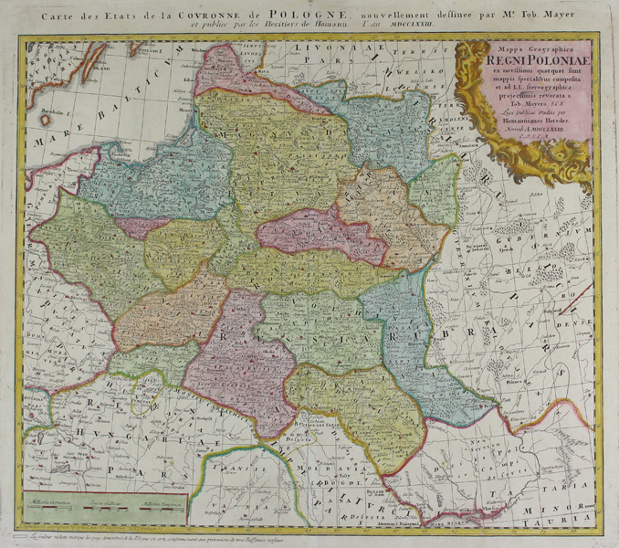
| Published | a Tob. Mayero. S.C.S. Luci publicae tradita per Homannianos Heredes. Norimb. A. MDCCLXXIII. C.P.S.C.M. [Nuremberg, 1773] |
| Dimensions | 438 x 505 mm |
| Notes |
Re-titled in French along top margin: Carte des Etats de la Couronne de Pologne nouvellement dessinee. A large and impressive map of Poland, published by the Homann Heirs for the Maior Atlas Superiore. The constituent voivodeships of Poland are shaded in full wash colour, and principal cities are picked out in red. Parts of Germany, Hungary, Transilvania, and the Ottoman Empire are also shown, with regional borders outlined in hand colour. In the top right, a large baroque cartouche encloses the title. The map is credited to Tobias Mayer (1723-1762), the celebrated German mathematician, astronomer, and cartographer. Johann Baptist Homann (20th March 1664 - 1st July 1724) was a German engraver and cartographer, and the Imperial Geographer to the Holy Roman Emperor Charles VI. In 1702 he opened a publishing house in Nuremberg, and his maps often make reference to his membership of the Prussian Royal Academy of Sciences and his imperial patronage. Upon his death, his maps passed to the Homann Heirs company and reprinted many times before the company closed in 1848. Condition: Central vertical fold, as issued. Minor time toning to edges of sheet. Manuscript '32' in top right corner of sheet. |
| Framing | unmounted |
| Price | £450.00 |
| Stock ID | 46846 |