
| Method | Copper engraved with hand colour |
| Artist | Speed, John |
| Published | Abraham Goos Amsteldamensis Sculpsit. Are to be sold by Roger Rea the Elder and younger at the Golden Crosse in Cornhill against the Exchange. [London, 1665] |
| Dimensions | 400 x 535 mm |
| Notes |
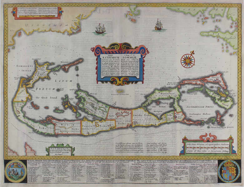
John Speed's map of the British Overseas Territory of Bermuda, here called the Sommer Isles, from the 1665 Roger Rea printing of his 'Prospect of the Most Famous Parts of the World.' The islands are shown with particular reference to the divisions of land according to the settlements of the Somer Isles Company, which in 1615 superseded the original colony established by the Virginia Company in 1609. The islands are divided up into Tribes, each outlined in hand colour, and further numbered divisions show the allotments allocated to each settler, here referred to as 'Adventurers.' An extensive key below the map lists the names of each individual, and is flanked by the crests of the Islands and the Crown. Farm buildings, churches, towns, and forts are picked out in red. Speed has employed an unusual but ingenious means of illustrating scale and location, a conceit he refers to proudly as 'curioslie ingraven and pourtrayed.' In addition to the main large scale map of the Islands, a diminutive Bermuda at the very centre of the sheet provides a perspective of size and distance to the coasts of Virginia, Cape Cod, and New England shown at top. Above the miniature Bermuda, a large strapwork cartouche provides a description of the colony's position in Latin and English. John Speed (1552-1629) is the most famous of all English cartographers primarily as a result of The Theatre of the Empire of Great Britaine, the first atlas of the British Isles. The maps from this atlas are the best known and most sought-after of all county maps. The maps were derived mainly from the earlier prototypes of Christopher Saxton and John Norden but with notable improvements including parish "Hundreds" and county boundaries, town plans and embellishments such as the coats of arms of local Earls, Dukes, and the Royal Household. The maps are famed for their borders consisting of local inhabitants in national costume and panoramic vignette views of major cities and towns. An added feature is that regular atlas copies have English text printed on the reverse, giving a charming description of life in the early seventeenth century of the region. The overall effect produced very decorative, attractive and informative maps. For the publication of his prestigious atlas, Speed turned to the most successful London print-sellers of the day, John Sudbury and George Humble. William Camden introduced the leading Flemish engraver, Jodocus Hondius Sr. to John Speed in 1607 because first choice engraver William Rogers had died a few years earlier. Work commenced with the printed proofs being sent back and forth between London and Amsterdam for correction and was finally sent to London in 1611 for publication. The work was an immediate success, with the maps themselves being printed for the next 150 years. Speed was born in 1552 at Farndon, Cheshire. Like his father before him he was a tailor by trade, but around 1582 he moved to London. During his spare time Speed pursued his interests of history and cartography and in 1595 his first map of Canaan was published in the "Biblical Times". This raised his profile and he soon came to the attention of poet and dramatist Sir Fulke Greville a prominent figure in the court of Queen Elizabeth. Greville as Treasurer of the Royal Navy gave Speed an appointment in the Customs Service giving him a steady income and time to pursue cartography. Through his work he became a member of such learned societies as the Society of Antiquaries and associated with the likes of William Camden, Robert Cotton, and William Lambarde. He died in 1629 at the age of seventy-seven. Abraham Goos (c.1590-1643) was a Flemish map-maker, engraver, and publisher. Although born in Antwerp, much of his career was spent in Amsterdam, where he worked as a map engraver for his uncle Pieter van den Keere, his cousin Jodocus Hondius, and his second-cousin Jan Jansson. He is best remembered for his work on Jansson's continuations of the Mercator-Hondius Atlas Minor and for his many terrestrial and celestial globes. His son, Pieter, followed in the family business and is celebrated for his Atlas ofte Water-Weereld, the greatest maritime atlas since Lucas Janszoon Waghenaer's Thresoor der Zeevaert. Condition: Central vertical fold as issued. Tear repairs to bottom of central fold. Infilling and tear repairs to top left corner of sheet. English text on verso. |
| Framing | unmounted |
| Price | £1,800.00 |
| Stock ID | 48469 |