
| Method | Etching and aquatint with hand colour |
| Artist | Lysons, Samuel |
| Published | [London, MDCCXCVII] |
| Dimensions | 440 x 630 mm |
| Notes |
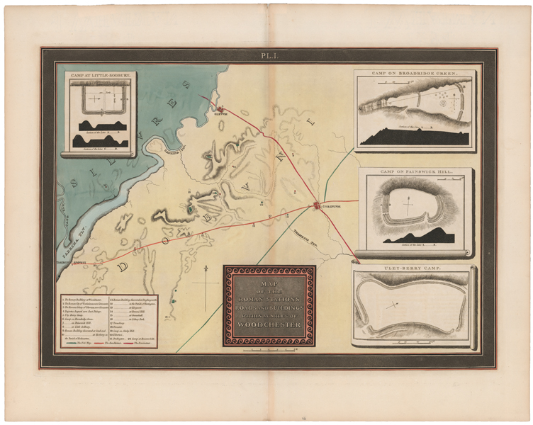
A large late eighteenth century map of the environs of Woodchester, Gloucestershire, during the Roman era, which was the first of a series of forty plates drawn by Samuel Lysons to accompany 'An Account of Roman Antiquities discovered at Woodchester in the County of Gloucester in the Year MDCCXCIII.' The map covers the traditional territory of the pre-Roman Celtic tribes of the Silures and Dobuni, on either side of the River Severn. The Roman towns of Glevum (Gloucester) and Corinium (Cirencester) are marked in red, as are the various forts, villas, and other Roman era structures of the region. The three principal ancient roads, the Fosse Way, the Icknield Way, and the Ermin Way, are also shown. A set of four inset maps, on scrolls, show the Camps at Little Sodbury, Broadridge Green, Painswick Hill, and Uley-Berry. Samuel Lysons (1763-1819) was a British engraver, author, and antiquarian. A prolific author, he is particularly celebrated for his work on Roman mosaics, the most notable of which was the very large and fine Orpheus mosaic he discovered in the Woodchester villa in Gloucestershire. Condition: Central vertical fold, as issued. Minor time toning to fold. 'J. Whatman 1794' watermark. Blank on verso. |
| Framing | unmounted |
| Price | £275.00 |
| Stock ID | 51647 |