
| Method | Steel engraved with original hand colour |
| Artist | Wyld, James |
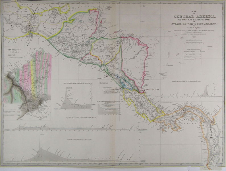
| Published | By James Wyld, Geographer to the Queen and H.R.H. Prince Albert. Charing Cross East. & Model of the Earth, Leicester SQe, London. 1853. [1854] |
| Dimensions | 590 x 805 mm |
| Notes |
A detailed map of Central America from James Wyld's A New General Atlas of Modern Geography. Map includes land from Vera Cruz in Mexico south to the Gulf of Darien, showing the possible crossings of the Isthmus, including Tehuantepic and the first geological survey of Panama. An inset map shows the geology of the Panama route and four sections display the altitude of the routes. In 1848, the discovery of gold in California not only caused would-be miners to flock to the Golden State, but also stimulated US interest in a cross-ocean canal. This would cut weeks off a journey to California and the gold fields. A numbers of surveys carried out between 1850 and 1875 concluded that the two most favourable routes were those across Panama and across Nicaragua, with a route across the Isthmus of Tehuantepec in Mexico as a third option. The map includes four trans-Isthmian profiles, showing the different proposed canal routes and their distances. It was originally published in a report to Congress. After the successful completion of the Suez Canal in 1869, the French were inspired to tackle a similar project which would connect the Atlantic and Pacific oceans. In 1876, an international company, La Société internationale du Canal interocéanique, was created to undertake the work. Ferdinand de Lesseps, who'd been in charge of the construction of the Suez Canal, was the figurehead of this scheme. However, unlike the desert home of the Suez, Panama hosts the the mountainous spine of Central America, which rises to a height of 110 meters above sea level at the lowest crossing point. Therefore, a sea-level canal, as proposed by de Lesseps, would require a prodigious excavation through harnesses of rock rather than through soft, desert sand. The prospects for a canal are presented in a box on the left hand side of the map titled: Isthmus of Panama. The map is coloured with reference to the geological makeup of the rock bed. The river and the brown colouring that make up the decomposed granite are well illustrated, being the easiest to move and dig through, a major reason for it being located there. Construction of the canal began on January the 1st 1881, however as early as 1885, it became clear that a sea-level canal was impractical, leading contractors to support an elevated canal. It was not until October 1887 that the lock-canal plan was adopted. In June 1902, the US Senate voted in favour of pursuing the Panamanian option. The map shows four sections: Across the Isthmus of Tehuantepec; from Port Sn. Juan del Norte to Port Realejo; between Charges (Atlantic) &c Vaca de Monte (Pacific); and from the Lake Nicaragua to Port San Juna del Sur. A large and very colourful inset shows the Isthmus of Panama and the planned route in great detail. P James Wyld (1812-1887) was a British publisher and cartographer. His greatest geographical achievement was Wyld's Great Globe, exhibited in Leicester Square between 1851 and 1862. The globe, sixty feet high and lighted with gas, was at that point the largest ever constructed. He was geographer to Queen Victoria and H.R.H. Prince Albert. Condition: Centre fold and two cuts and folding at lower right corner, as issued. Some foxing and discolouration in margins. |
| Framing | unmounted |
| Price | £250.00 |
| Stock ID | 41863 |