
| Method | Copper engraved with hand colour |
| Artist | Homann, Johann Baptist |
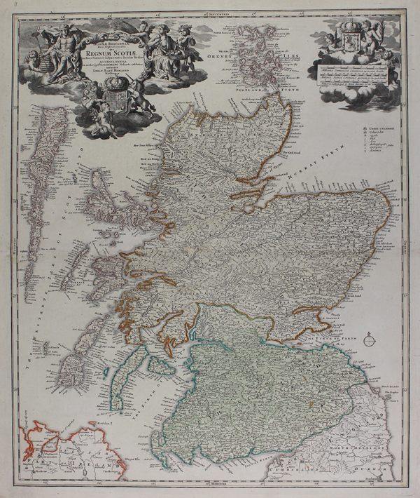
| Published | Accurata Tabula ex archetypo Vischeriano desumta exhibetur imitatore Iohan. Bapt. Homanno Noribergae. [Nuremberg, c. 1729] |
| Dimensions | 570 x 470 mm |
| Notes |
A superb and highly decorative early eighteenth century map of Scotland, from the Maior Atlas Superiore. The country is divided into 'North Scotland' and 'South Scotland,' with the borders of each outlined in hand colour. Although the Hebrides and the Orkney Islands are shown in detail, the Shetland Islands are not shown. In the top left corner, the title is enclosed in a baroque cartouche flanked by agrarian figures, as well as the Royal Arms supported by the lion and unicorn. In the top right, the Royal Arms of Scotland are held aloft by a trio of cherubs above a scale in German, Scottish, and French miles. Johann Baptist Homann (20th March 1664 - 1st July 1724) was a German engraver and cartographer, and the Imperial Geographer to the Holy Roman Emperor Charles VI. In 1702 he opened a publishing house in Nuremberg, and his maps often make reference to his membership of the Prussian Royal Academy of Sciences and his imperial patronage. Upon his death, his maps passed to the Homann Heirs company and reprinted many times before the company closed in 1848. Condition: Central horizontal fold, as issued. Marginal chips and tears, not affecting map, professionally repaired. Blank on verso. |
| Framing | unmounted |
| Price | £500.00 |
| Stock ID | 50654 |