
| Method | Copper engraved with hand colour |
| Artist | Hondius, Henricus |
| Published | Amsterdam, c.1633 |
| Dimensions | 377 x 508 mm |
| Notes |
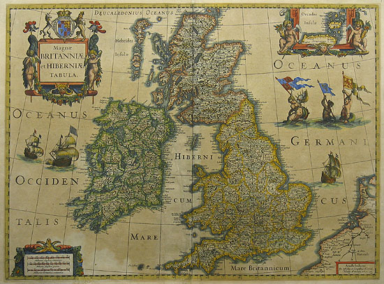
German text on verso A finely engraved, boldly embellished map of the British Isles from the most important Dutch map publishers of the 17th century, densely packed with information. It includes an inset of the Orkney Islands enclosed in a cartouche flanked by putti. The map is further adorned with sailing ships, mermaids displaying armorial flags and elaborate title and distance scale cartouches. This was one of several maps introduced by Hondius and Jansson in response to increased competition from their rival Willem Blaeu. A the end, this market pressure also resulted in the Hondius-Jansson atlas being issued in English, which was very unusual for Dutch publications of this period. Although dated 1631, this map only appeared in the Hondius-Jansson Atlas between 1633 and 1644. Until the early 1980s it was thought that this map had been newly engraved in 1630/31 as part of the major effort mounted by Jan Jansson and Henricus Hondius to meet growing competition from the Blaeu family. However, for his British Isles map Hondius (like Blaeu) drew on an earlier plate - the bordered plate first engraved by him in 1617. The borders have now been cut off and the date 1631 added to Hondius' imprint in the lower right-hand corner. Ref: Shirley, Early Printed Maps Of The British Isles, 462 (435) Condition: Strengthening to creases on verso. Centerfold as issued. |
| Framing | unmounted |
| Price | £1,200.00 |
| Stock ID | 27548 |