
| Method | Copper engraved with hand colour |
| Artist | Merian, Matthäus |
| Published | M. Merian fecit. [Frankfurt, c. 1650] |
| Dimensions | 269 x 354 mm |
| Notes |
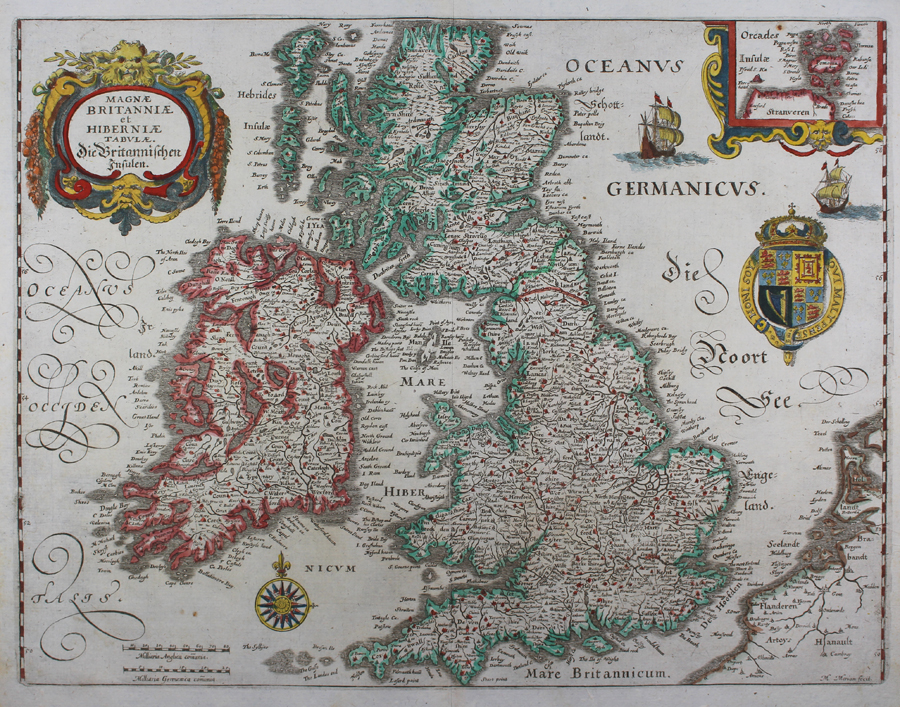
A fine seventeenth century map of the British Isles, based on Blaeu, from Merian's Theatrum Europaeum. Sea coasts and country borders are outlined in hand colour, and principal cities are picked out in red. On the other side of the English Channel, the coasts of Flanders and Holland are depicted. Two sailing ships occupy the German Ocean (North Sea), and a decorative compass rose sits above a scale in English and German miles in the Irish Sea. In the top right corner, a boxed inset map depicts the Orkney Islands, and the map is further embellished with a large baroque title cartouche and the Royal Crest. Cartographically, the map follows Blaeu's 1631 map of the British Isles. Matthäus Merian the Elder (22 September 1593 - 19 June 1650) was a Swiss engraver born in Basel. Beginning his career in Zürich where he learned the art of copperplate engraving, Merian went on to study and work in various cities throughout France. In 1615, Merian returned to Basel. His return to Basel, however, was short lived, moving to Frankfurt the following year to work for the publisher Johann Theodor de Bry. Merian later married de Bry's daughter. He was also the father of Maria Sibylla Merian, one of the greatest natural history artists of the late 17th and early 18th centuries. Condition: Central vertical fold as issued. Some foxing to sheet edges. Spot of rust to inset map and to sea off southern Irish coast. |
| Framing | unmounted |
| Price | £500.00 |
| Stock ID | 51039 |