
| Method | Copper engraved with hand colour |
| Artist | Moll, Herman |
| Published | London: Printed for the Proprietor Carington Bowles, at his Map and Print Warehouse, No. 69, St Paul's Church Yard. MDCCLXXXIV [1784] |
| Dimensions | 153 x 224 mm |
| Notes |
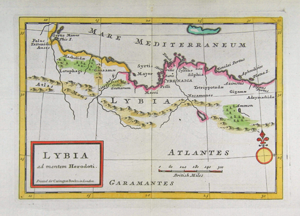
A map of the ancient North African coast, from Bowles' Geographia Classica, or the Geography of the Ancients, as contained in the Greek and Latin Classics. The map depicts the region of North Africa known to the Greeks as Libya, an area encompassing modern-day Libya, Tunisia, Algeria, Morocco, and part of western Egypt, following the Histories of Herodotus. In addition to the native Berber tribes, the coast was occupied by Phoenician and Greek settlers, who established colonies in the region from the eighth century BC onwards. The area of greatest Greek activity came to be known as Cyrenaica, after the principal city of this stretch of coastline, Cyrene. The coastline of Cyrenaica is outlined in hand colour, as are the neighbouring parts of Libya, the island of Crete, and principle forests and mountain ranges. The 'lotophagi' of Greek mythology are also plotted, in the forests of the Tunisian coast, and the oracular sanctuary of Ammon is shown in the Libyan desert. Herodotus (c.484-425 BC) was a Greek historian from the Ionian city of Halicarnassus, now Bodrum, in modern Turkey. His Histories, the first known work to approach a historical subject from a position of enquiry, earned him the title of 'Father of History.' The Histories sought to trace the origins of the 5th century BC Persian Wars, drawing upon Greek geographic and ethnographic knowledge of the Persian Empire. Bowles' Geographia Classica, or the Geography of the Ancients, as contained in the Greek and Latin Classics was undertaken by Herman Moll as a supplement to the many eighteenth century editions of Greek and Latin classics published by Carington Bowles and his contemporaries. Most editions contained a total of 32 maps in an arrangement similar to Ortelius' famous Parergon, depicting the kingdoms and provinces of the Greek and Roman world, elucidating particular texts such as 'Caesar's Gaul' or the 'Journeys of Aeneas,' and including a number of biblical maps. Unlike the Parergon, which was accompanied by Ortelius' copious notes and commentary, Moll's Geographia Classica contained no explanatory text, with the frontis instead explaining that the atlas was 'Principally designed for the Use of Schools, as being accomodated for the more easy and clear Understanding of the Ancient Authors.' The list as given by Moll included Homer, Herodotus, Justin, Virgil, Ovid, Florus, Nepos, Caesar, Livy, Lucan, and Plutarch. Herman Moll (c.1654-1732) was born in Germany and came to England in the 1670s. He worked as an independent cartographer and geographer, and traded as a map publisher and seller for two years, and then worked for other publishers. Moll established his own business and eventually dominated the early eighteenth century map trade. He produced many maps and atlases of England, Wales, Scotland and Ireland. His county maps were all boldly engraved in a heavy style. Moll was also an active member in academic and intellectual circles, being a close associate of Daniel Defoe, Robert Boyle, Robert Hooke, and, most importantly for his cartographic career, the pre-eminent English explorer of the era, William Dampier. Condition: Central vertical fold as issued. |
| Framing | mounted |
| Price | £50.00 |
| Stock ID | 41375 |