
| Method | Copper engraved with hand colour |
| Artist | after Bonne, Rigobert |
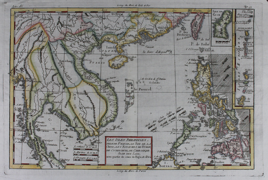
| Published | Par M. Bonne, Ingénieur-Hydrographe de la Marine. André sculp. [Geneva, 1783] |
| Dimensions | 220 x 325 mm |
| Notes |
A detailed eighteenth century French map of South East Asia, from l'Abbé Raynal's 'Atlas de Toutes les Parties Connues du Globe Terrestre, dressé pour l'Histoire Philosophique et Politique des Établissemens et du Commerce des Européens dans les Deux Indes.' The borders of the various kingdoms and nations of the region are outlined in hand colour, and the dates and directions of the trade winds to Manilla are shown as heavily fletched arrows. The map encompasses parts of modern day China, Taiwan, Vietnam, Cambodia, Thailand, Burma (Myanmar), Malaysia, Borneo, and the Philippines. Along the right hand side, two boxed inset maps show the Island of Guam and the Mariana islands. This printing lacks Bonne's imprint to title block and has a slight variant in text, suggesting this may be a pirated copy or later issue. A major cartographer of the late 18th century, Rigobert Bonne (1727-1795) was Royal Cartographer to France, succeeding Jacques Nicolas Bellin in the office of the Hydrographer at the Depôt de la Marine. Bonne produced some of the most detailed and precise maps of the period. Bonne's maps represent a departure from the more decorative maps of the previous century, and although much of his cartographic style can be traced to his predecessor, Bellin, Bonne maps are generally less decorative, characteristically lacking ornate cartouches, compass roses, or contemporary hand colour. Condition: Central vertical fold, as issued. Top right corner of sheet torn, not affecting map. Minor creasing to margins, not affecting map. |
| Framing | unmounted |
| Price | £225.00 |
| Stock ID | 47365 |