
| Method | Lithograph |
| Artist | Dower, John James |
| Published | by John Dower, F.R.G.S. London, Published by Cassell, Petter, & Galpin, La Belle Sauvage Yard, Ludgate Hills, E.G. [c.1867] |
| Dimensions | 310 x 450 mm |
| Notes |
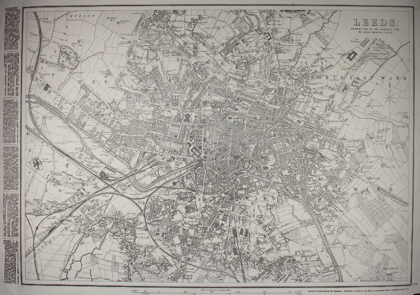
A mid-Victorian map of the city of Leeds, originally drawn by John Dower for the Weekly Dispatch, but here separately reprinted by Cassell, Petter, & Galpin, with descriptive text along the left hand margin. The map shows the city in high detail, down to the footprint of individual houses and buildings. Railways and rail tunnels are shown, and ward boundaries are marked as dashed lines. Following the printing of the Dispatch Atlas, the plates were sold to Cassell, Petter, & Galpin who issued the maps separately between 1863 and 1867, before publishing them together again as 'Cassell's Atlas.' By the mid 1870s, the plates had passed to George Bacon, who issued them again under the title of 'Bacon's New Quarto Atlas of the Counties of England.' Between 1857 and 1863, the British newspaper The Weekly Dispatch published a series of maps. Over 100 maps were produced, and in 1863, the maps were gathered together to form The Dispatch Atlas. The atlas contained county and country maps, as well as several city maps. Each of the maps featured a distinctive image of a half-globe with a winged mercury above. John James Dower (1825-1901) was a British cartographer, engraver, lithographer, and draughtsman. The son of the cartographer and engraver John Crane Dower (1791-1847), he was elected a Fellow of the Royal Geographic Society in 1854. Although he issued maps under his own imprint, he was best known for being a prolific contributor to the Weekly Dispatch Atlas. Condition: Tears to bottom edge of sheet, without loss to map. Pressed horizontal and vertical folds. Water staining to right margin, not affecting map. |
| Framing | unmounted |
| Price | £45.00 |
| Stock ID | 49104 |