
| Method | Copper engraved with hand colour |
| Artist | Ortelius, Abraham |
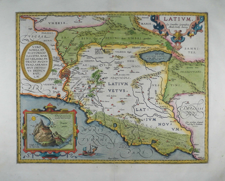
| Published | Ex Conatibus Geographicis Abrah. Ortelij Antverp. [1595 Parergon Edition] |
| Dimensions | 353 x 450 mm |
| Notes |
An early state of Ortelius' map of ancient Italian region of Latium, modern Lazio, from the 1595 Parergon (Supplement) of Ortelius' famous Theatrum Orbis Terrarum. The map depicts the extent of Latium Vetus and Latium Novum, as well as adjoining parts of Tuscia, Umbria, and Campania. The map is ornamented in beautiful hand colour. Principal cities and towns are picked out in red, and the map is heavily annotated with references from the classical source tradition for the various cities, settlements, and myths of ancient Latium. On the border of Etruria and Latium is the Tiber River, with the walled city of Rome depicted in detail. A number of Rome's most representative monuments are also depicted, including the Pantheon, the Colosseum, and the dome of St Peters. The ancient Latin tribes, including the Rutuli, Hernici, Aborigines, Latini, and Sicani, are listed across the region, as are significant geographical features like the Pontine Marshes, the Alban Hills, and the Fucine Lake. The map also plots the locations of villas, including those of Lucullus, Cicero, Pliny, and Hadrian, as well as the Tomb of the Scipios, the sanctuary of Juno Sospita, the Shrine of Juturna, the Harbour of Portus, and numerous other points of classical interest. Ortelius, as much a bibliophile as a philologist, pays great attention to the monastery at Subiaco, where in 1465, a group of German monks printed the first book in Italy, an edition of the works of Lactantius. The map is further embellished by a trio of decorative cartouches. The first, in decorative strap-work, encloses the title. The second, in an oval egg-and-dart pattern border, contains a dedication to Ortelius' friend Markus Welser, a German humanist, historian, and antiquarian of Augsburg, who is best remembered for his study of the famous Tabula Peutingeriana, a medieval copy of a Roman map of the imperial road system, the cursus publicus. Later editions of Ortelius' map of Latium feature the addition of the Roman road network, and his engraved copy of the Tabula Peutingeriana was published in posthumous copies of the Parergon. Finally, in the bottom left corner of the map, a strap-work cartouche contains an inset view of Mons Circeius, the mythical home of Circe, the witch featured in Homer's Odyssey. The promontory, now home to the modern village of San Felice Circeo, was the location of a Roman colony from at least as early as the 4th century BC, but the citadel and walls were likely of an earlier date. On the verso, a lengthy history of Latium includes a monumental feat of philological collation, in which Ortelius lists in three columns every descriptive or poetic title for the City of Rome found in the classical corpus, complete with attributions to the relevant ancient authors. A similar description for Mons Circeius preserves the text of a damaged dedicatory inscription, as well as a pair of coins featuring ships prows and portraits of the Italic gods Saturn and Janus. The Parergon ('Supplement') was, as the title suggests, originally conceived of as a supplement to Ortelius' Theatrum. The work, a massive and intricately researched index of the classical world, was accompanied by a series of ancient world maps. Unlike the maps of the Theatrum, the majority of which were reductions of earlier maps, the maps of the Parergon were researched and drawn by Ortelius himself. The work was a huge commercial success, and the maps themselves set the standard for ancient world maps for the duration of the seventeenth century, being reproduced or reprinted by various publishers after Ortelius' final 1624 printing. His interest in the mapping of the ancient world is manifest. The maps of the Parergon are a veritable mine of textual commentary and classical philology, drawing upon Ptolemy, Strabo, Pliny, and many others. Interestingly, the project seems to have been a labour of love, rather than a mercantile venture. Ortelius himself was fascinated with the ancient world, and a formidable classical scholar in his own right. In addition to his work as a cartographer, he dealt in antiquities, visited and surveyed ancient sites across Europe, published a critical edition of Caesar's Gallic Wars in 1593, and assisted Welser in his studies of the famous Tabula Peutingeriana in 1598, producing an engraved copy of the map that can be found in later editions of the Parergon. Abraham Ortelius (1527 -1598) was a Flemish cartographer, cosmographer, geographer and publisher and a contemporary of Gerard Mercator, with whom he travelled through Italy and France. Although it is Mercator who first used the word "Atlas" as a name for a collection of maps, it is Ortelius who is remembered as the creator of the first modern atlas. Theatrum Orbis Terrarum was the first systematically collated set of maps by different map makers in a uniform format. Three Latin editions as well as a Dutch, French and German edition of Theatrum Orbis Terrarum were published by 1572 and a further 25 editions printed before Ortelius' death in 1598. Several more were subsequently printed until around 1612. Ortelius is said to have been the first person to pose the question of the continents once being a single land mass before separating into their current positions. Condition: Clean, crisp impression with full margins. Central vertical fold as issued. Crossed arrows watermark. |
| Framing | mounted |
| Price | £750.00 |
| Stock ID | 41515 |