
| Method | Copper engraved with hand colour |
| Artist | van den Keere, Pieter |
| Published | Petrus Kaerius Cœlavit [c. 1661] |
| Dimensions | 158 x 198 mm |
| Notes |
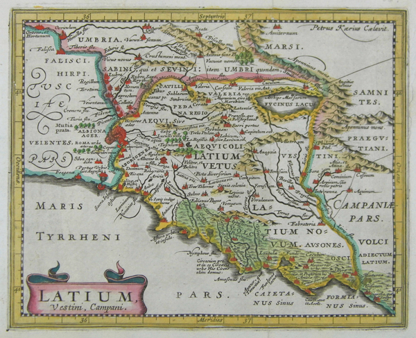
A map of ancient Latium, now the region of Lazio in Italy, engraved by van den Keere for a later printing of Philipp Clüver's Italia Antiqua, originally published in 1624 with maps by Petrus Bertius. The map records numerous Roman-era settlements, towns, and cities, as well as the territories of the various pre-Roman Latin peoples. The city of Rome itself is depicted in some detail, the Aurelian walls clearly visible encircling the city and the Tiber island. The city, like numerous other principal locations, is picked out in red, and the borders of Latium and the adjoining regions of Tuscany, Umbria, and Campania are outlined in hand-colour. The various ranges of the Apennines are washed in brown, while the marshland along the Latian coast is shaded in green. Principal Roman roads are also marked and labelled. Pieter van den Keere, also known frequently as Petrus Kaerius, came to England in 1584, as a Protestant refugee from his home town of Ghent with his sister Colette, who married Jodocus Hondius, in 1587. It was probably from Hondius that Keere learned to engrave. Both engravers left London in 1593 to settle in Amsterdam. Keere began to engrave a series of miniature maps in 1599 in preparation for a small atlas of the British Isles. The maps were first published in 1617 by William Blaeu with plate numbers and Latin text. They then passed to George Humble, who published them in 1619 and then again in 1627, by which time they had become known colloquially as 'Miniature Speeds.' Condition: Vertical folds as issued. Professional tear repair to right margin and plate mark, not affecting image. |
| Framing | unmounted |
| Price | £120.00 |
| Stock ID | 40840 |