
| Method | Copper engraved |
| Artist | Van Jagen, Jan |
| Published | J. v. Jagen sculps. et dir. [Keur, Dordrecht, c.1748] |
| Dimensions | 305 x 450 mm |
| Notes |
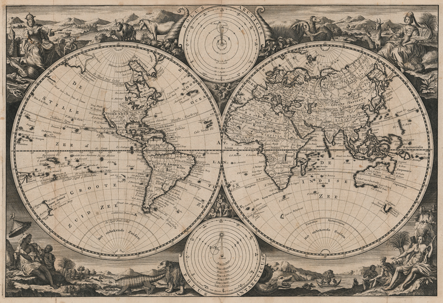
A finely engraved double hemisphere Dutch world map, engraved by Jan van Jagen as a replacement for the popular Stoopendaal plate, which was used for numerous world maps issued in the Keur family's Dordrecht bibles.Stylistically and cartographically, the map is a close copy of Stoopendahl's earlier plate, itself deriving from the slightly larger 1658 world map by Visscher and Berchem, which was ultimately derived from Blaeu's 1648 map. In addition to translating the map's textual annotations into Dutch from the original Latin, van Jagen's map also provided some updated geographical features from Stoopendaal's relatively conservative cartography. Chief amongst these are the reinstating of a peninsular California for the earlier flat topped island, the removal of the putative northern coast above California, and a greater degree of accuracy in mapping the region around the suggested northwestern passages between Hudson Bay and Baffin Island. The majority of the northern and eastern coastlines of Australia are mapped, though the eastern coast is absent, and the Cape York Peninsula is effectively connected to New Guinea, though there remains a tiny break in the coastline. Tasmania is partially mapped, as is a partial coastline of New Zealand in the western hemisphere. Antarctica is completely absent, and in the Arctic, only parts of Novaya Zemlya, Greenland, and Svalbard are shown. In the earlier Visscher map, a pair of smaller roundels between the hemispheres showed the Poles, though in Stoopendaal's bible maps, as retained here by van Jagen, these are replaced by models of the orbits in our solar system, on heliocentric and geocentric patterns. Curiously the earlier titles, Polus Arcticus and Polus Antarticus, remain, flanked by sirens and silens, and supported by groups of cherubs. Unlike earlier examples, which featured a banner along the top margin, a ribboned cartouche, or simply a text title in the blank spaces flanking the smaller roundels, van Jagen's map is untitled. The remaining space between the hemispheres and the border is occupied by a quartet of scenes representing the four continents, with allegorical figures accompanied by representatives of the flora and fauna of the four corners of the world. In the top left, Europa is shown as Queen of Nations, holding a sceptre and wearing a crown, while representatives of Asia and Africa bring forth gifts for presentation. Emblems of the Arts and Sciences lie at her feet, and domesticated beasts stand before cultivated fields. To top right, Asia, in flowing robes and a turban, holds an incense burner, flanked by an elephant, a camel, and a pair of giraffes near an oasis. Africa, in the bottom left, is represented by two dark-skinned figures sheltering under a parasol in a landscape populated by lions and a crocodile. In the Americas, a group of bare-breasted figures wear feathered headdresses, while an enormous dragon or serpent hisses in the corner. Jan van Jagen (1707-1800) was a Dutch printmaker and publisher who specialised in maps. He lived and worked in Amsterdam. His brother Carl van Jagen was also an engraver. Daniel Stoopendaal (1672-1726) was a Dutch engraver, mapmaker, and publisher, based in Amsterdam. The son of the printmaker Bastian Stoopendaal, he was active in Amsterdam, and is best known for producing world maps after Visscher, and plates of Dutch town houses and country estates for de Leth. Many of his maps were included in bibles published by the Keur family. The Visscher family produced maps and atlases in Amsterdam throughout the seventeenth and early eighteenth century. Established by Claes Janszoon Visscher (1587-1652), they mainly published atlases from plates purchased from Pieter van den Keere. The business was then continued by Claes' son Nicolas Visscher I (1618-1679) and his grandson Nicolas II. The Visschers published many revised editions of their 'Atlas Contractus' and 'Atlas Minor'. Upon the death of Nicholas II, his wife, Elizabeth, continued the business before selling it to Pieter Schenk. Condition: Vertical folds as issued. Minor foxing to plate, particularly to central vertical fold. Minor repaired tears to edges of sheet, and to folds. Dutch text on verso. |
| Framing | unmounted |
| Price | £1,400.00 |
| Stock ID | 51938 |