
| Method | Steel engraved with hand colour |
| Artist | Rapkin, John |
| Published | John Tallis & Company, London & New York. The Illustrations by H. Warren & Engraved by J.H. Kernot. The Map Drawn & Engraved by J. Rapkin [c.1850] |
| Dimensions | 219 x 295 mm |
| Notes |
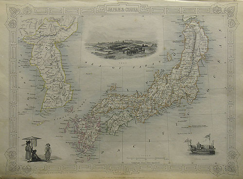
A decorative map of Japan and Korea, from Tallis' Illustrated Atlas. The provinces of Japan are outlined in hand colour, with a different colour scheme for each island. The map is surrounded with vignettes including a large prospect of Yedo (Tokyo), a trio of figures in Korean dress, and an illustration of the State Barge. The border features a geometric pattern with floral corners. John Tallis was a British publisher and one of the most popular cartographers of the 19th Century. Tallis maps were highly valued for their accuracy, but perhaps more so for their charming vignettes and ornamentation. Engraved by John Rapkin, these maps were praised by the New York Sun as "the most accurate and most splendid publication of the kind ever issued". The Bristol Times observed that Mr. Tallis maps "are not only critically correct, but are accompanied with elegant and appropriate engravings illustrative of the manners and costumes of the different countries." John Rapkin was an engraver and mapmaker active in Britain in the mid-nineteenth century. He drew and engraved the maps for John Tallis' 'The Illustrated Atlas and Modern History of the World' (1845-51), which was later re-issued by the London Printing and Publishing Company. He also drew and engraved maps for R. Montgomery Martin's 'British Colonies, their history' (1849), and Wright's 'Universal Pronouncing Dictionary' (c.1850). Condition: Centrefold as issued. |
| Framing | unmounted |
| Price | £140.00 |
| Stock ID | 25748 |