
| Method | Woodcut |
| Artist | Münster, Sebastian |
| Published | [Henricus Petri, Basel, c.1572] |
| Dimensions | 265 x 340 mm |
| Notes |
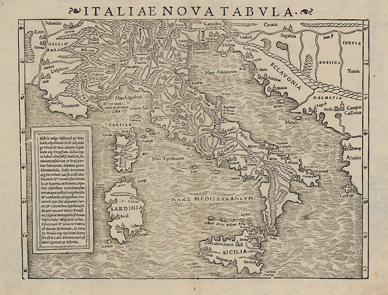
A mid-sixteenth century woodcut map of Italy, from the 1572 Latin edition of Münster's celebrated Cosmographia. One of the very earliest maps of the Italian peninsula not based upon Ptolemy, Munster's map also contains parts of the Dalmatian coast, southern France, Sicily, Corsica, and Sardinia. Principal cities are plotted pictorially, and mountain ranges, including the Apennines and the Alps are shown. A large descriptive text in Latin is included in a box to the map's left, outlining the different regions of Italy and their history. Sebastian Münster (20th January 1488 - 26th May 1552) was a German cartographer, cosmographer, and theologian. A gifted scholar of Hebraic, Münster originally joined the Franciscans, but left the order in favour of the Lutheran Church. He was appointed to the University of Basel in 1529, and published a number of works in Latin, Greek, and Hebrew. His most celebrated works are his Latin edition of Ptolemy's Geographia in 1540, and the Cosmographia in 1544. The Cosmographia was the earliest German description of the world, an ambitious work of 6 volumes published in numerous editions in German, Latin, French, Italian, and Czech. Henricus Petrus (1508-1579) was a German printer and published, whose print-works in Basel produced some of the most influential works of the German Renaissance, including Copernicus' De revolutionibus orbium coelestium and Munster's Cosmographia. Condition: Central vertical fold, as issued. Minor time toning to edges of sheet. Latin letterpress text on verso. |
| Framing | unmounted |
| Price | £700.00 |
| Stock ID | 53151 |