
| Method | Copper engraved with hand colour |
| Artist | Ortelius, Abraham |
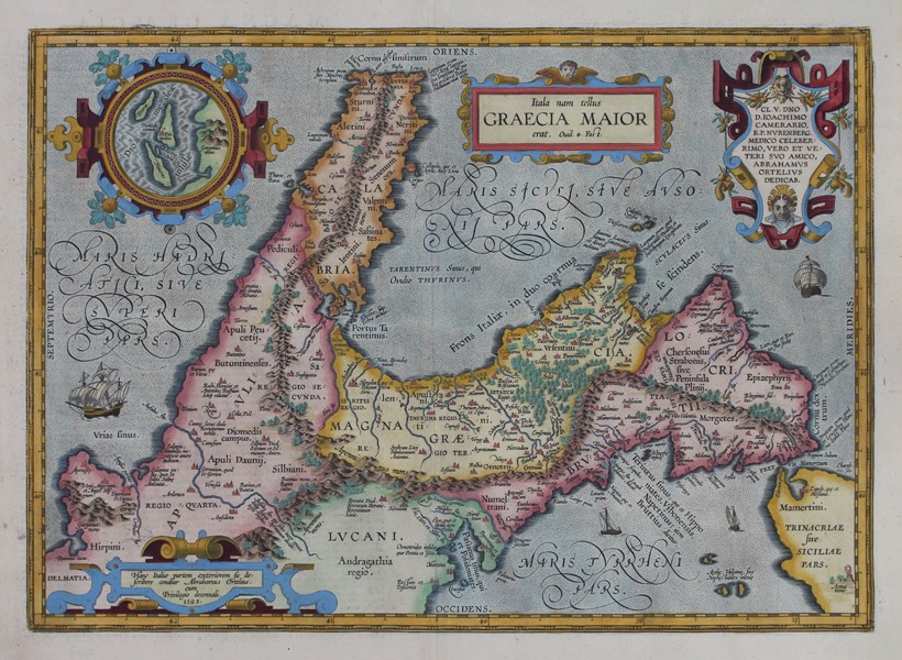
| Published | Hanc Italiae partem exteriorem sic describere conabar Abrahamus Ortelius, cum Privilegio decennali, 1595 [1603 Parergon] |
| Dimensions | 340 x 476 mm |
| Notes |
A map of Southern Italy, in antiquity often called Magna Graecia or 'Great Greece' after the many Greek colonies there, from the 1603 Latin Parergon (Supplement) of Ortelius' famous Theatrum Orbis Terrarum. The map is oriented with south to top, and depicts Magna Graecia at centre, bounded by the Tarentine Gulf to the south, and the Apennine Mountain range to the north, east, and west. Parts of the surrounding areas of Calabria, Apulia, Lucania, Brutium, Epizyphrian Locris, and Sicily are also featured. The map is ornamented in beautiful hand colour. Principal cities and towns are picked out in red, and the map is heavily annotated with references from the classical source tradition for the various cities, settlements, and myths of ancient Magna Graecia. Among the latter, the monsters Scylla and Charybdis from the Odyssey are depicted in the Mamertine straits, the tomb of Hyacinthus is shown near the Spartan colony of Tarentum, the Fields of Diomedes occupy much of the plains of Apulia, the southernmost tip of Calabria is named Iapygia after Iapyx, Aeneas' healer and favourite of Apollo, and the islands of Ogygia, home of the titaness Calypso, are plotted off the coast of the city of Croton. The map is further embellished with a set of four decorative cartouches. The first, in the top left corner of the map, features a circular inset plan of the 'islands of Diomedes,' off the coast of Apulia near Mt Garganus and the city of Salapia, listed as having been made famous 'by Hannibal's love for a courtesan.' The second is enclosed by a strap-work design featuring garlands of fruit and a pair of Greek theatrical masks, and includes a dedication to the German classical scholar Joachim Camerarius. The final two, also surrounded by strap-work, contain the title, taken from a passage in Ovid's Fasti, and the publisher's inscription. The verso features a lengthy description in Latin of the history and source tradition for the region. The Parergon ('Supplement') was, as the title suggests, originally conceived of as a supplement to Ortelius' Theatrum. The work, a massive and intricately researched index of the classical world, was accompanied by a series of ancient world maps. Unlike the maps of the Theatrum, the majority of which were reductions of earlier maps, the maps of the Parergon were researched and drawn by Ortelius himself. The work was a huge commercial success, and the maps themselves set the standard for ancient world maps for the duration of the seventeenth century, being reproduced or reprinted by various publishers after Ortelius' final 1624 printing. His interest in the mapping of the ancient world is manifest. The maps of the Parergon are a veritable mine of textual commentary and classical philology, drawing upon Ptolemy, Strabo, Pliny, and many others. Interestingly, the project seems to have been a labour of love, rather than a mercantile venture. Ortelius himself was fascinated with the ancient world, and a formidable classical scholar in his own right. In addition to his work as a cartographer, he dealt in antiquities, visited and surveyed ancient sites across Europe, published a critical edition of Caesar's Gallic Wars in 1593, and assisted Welser in his studies of the famous Tabula Peutingeriana in 1598, producing an engraved copy of the map that can be found in later editions of the Parergon. Abraham Ortelius (1527 -1598) was a Flemish cartographer, cosmographer, geographer and publisher and a contemporary of Gerard Mercator, with whom he travelled through Italy and France. Although it is Mercator who first used the word "Atlas" as a name for a collection of maps, it is Ortelius who is remembered as the creator of the first modern atlas. Theatrum Orbis Terrarum was the first systematically collated set of maps by different map makers in a uniform format. Three Latin editions as well as a Dutch, French and German edition of Theatrum Orbis Terrarum were published by 1572 and a further 25 editions printed before Ortelius' death in 1598. Several more were subsequently printed until around 1612. Ortelius is said to have been the first person to pose the question of the continents once being a single land mass before separating into their current positions. Condition: Clean, crisp impression with full margins, presented in full wash colour. Central vertical fold as issued. Minor time toning to edges of sheet, not affecting map or plate. Latin text on verso. |
| Framing | unmounted |
| Price | £900.00 |
| Stock ID | 51213 |