
| Method | Copper engraved with hand colour |
| Artist | van den Keere, Pieter and Jansson, Jan |
| Published | Petrus Kaerius Caelavit. Amstelodami apud Ioannem Ianssonium [Amsterdam, 1646] |
| Dimensions | 392 x 508 mm |
| Notes |
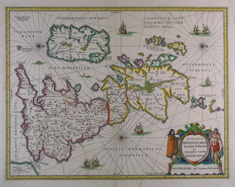
A map of Roman and ancient Britain, oriented with west to top, from Jansson's Atlas Major. England and Wales are labelled as Britannia Superior, and further divided into the later Roman provinces of Prima (the South), Secunda (Wales), Flavia Caesariensis (the Midlands), and Maxima Caesariensis (the North). Scotland is labelled using both its early and later Roman titles, as Britannia Inferior and the province of Valentia. Hibernia (Ireland), the Orcades, and the Hebrides are also labelled. Principal cities and towns are picked out in red, as are the two Roman era walls built by Hadrian and Antoninus Pius, here labelled as Severan. Original celtic tribal regions are also labelled, as well as the site that Caesar allegedly landed in his invasion of 55 BC. The map is embellished with a large baroque strapwork cartouche in the bottom left corner, containing the name of the publisher, the title, and a dedication to Abraham Ortelius. The figures on either side of the cartouche are representations of moustachioed and tattooed ancient Britons. The map is closely based upon the earlier Ortelius map of Roman Britain, which first appeared in the Parergon, and it is likely that this map was printed from the same, though heavily reworked, plate. Text and cartography are almost identical, though van den Keere has re-engraved much of the surrounding ornamentation, including new and more numerous ships and sea monsters, has removed the original cartouches and replaced them with those of Jansson, and has added three compass roses and corresponding rhumb lines to the oceans. Pieter van den Keere, also known frequently as Petrus Kaerius, came to England in 1584, as a Protestant refugee from his home town of Ghent with his sister Colette, who married Jodocus Hondius, in 1587. It was probably from Hondius that Keere learned to engrave. Both engravers left London in 1593 to settle in Amsterdam. Keere began to engrave a series of miniature maps in 1599 in preparation for a small atlas of the British Isles. The maps were first published in 1617 by William Blaeu with plate numbers and Latin text. They then passed to George Humble, who published them in 1619 and then again in 1627, by which time they had become known colloquially as 'Miniature Speeds.' Johannes Janssonius (1588 - 1664) was a famed cartographer and print publisher. More commonly known as Jan Jansson, he was born in Arnhem where his father, Jan Janszoon the Elder, was a bookseller and publisher. In 1612 he married the daughter of the cartographer and publisher Jodocus Hondius, and then set up in business in Amsterdam as a book publisher. In 1616 he published his first maps of France and Italy and from then onwards, produced a very large number of maps which went some way to rival those of the Blaeu family, who held a virtual monopoly over the industry. From about 1630 to 1638 he was in partnership with his brother-in-law, Henricus Hondius, issuing further editions of the Mercator/Hondius atlases to which his name was added. On the death of Hondius he took over the business, expanding the atlas still further, until eventually he published an eleven volume Atlas Major on a scale similar to Johannes Blaeu's magnum opus. After Jansson's death, his heirs published a number of maps in the Atlas Contractus of 1666, and, later still, many of the plates of his British maps were acquired by Pieter Schenk and Gerard Valck, who published them again in 1683 as separate maps. Condition: Strong dark impression. Central vertical fold as issued, with minor tear repair to bottom of vertical crease. Minor printer's creases to right side of map. |
| Framing | unmounted |
| Price | £800.00 |
| Stock ID | 42094 |