
| Method | Copper engraved with hand colour |
| Artist | Blaeu, Willem Janszoon |
| Published | [Amsterdam, c.1640] |
| Dimensions | 380 x 498 mm |
| Notes |
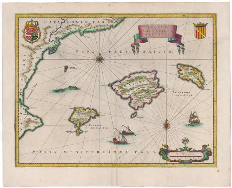
A large and decorative early seventeenth century map of the Balearic Islands, encompassing Mallorca, Menorca, Ibiza, and Formentera, as well as parts of the Valencian and Catalonian coasts, from a Latin edition of Blaeu's Atlas Novus. The coasts of the islands and neighbouring provinces are outlined in hand colour, principal cities and towns are picked out in red, and forests and mountain ranges are shown pictorially. Rhumb lines crisscross the Balearic sea, radiating from a pair of compass roses. A pair of sea monsters spar in the waters east of Valencia, while a pair of oared galleys and a sailing ship ply the Mediterranean. The title and a scale in Spanish miles are enclosed in ribbon and strapwork cartouches, and a pair of armorials depicting the Royal Arms of Spain and Portugal, and the Arms of the Balearic Islands, are featured at top left and top right respectively. The Blaeu family were one of the most famous publishers of maps, globes and atlases during the seventeenth-century. Cartographers, globe makers and booksellers, the Blaeu business flourished in Amsterdam for over 40 years, until a fire destroyed their premises in 1672. They lost all of their plates, prints and stock, which effectively ruined the firm. Willem Blaeu founded the business in 1596. It initially functioned as a globe and instrument makers, but soon expanded into maps, topography and sea charts. The Atlas Novus was Willems great work; a major work which intended to include the most up-to-date maps of the entire world. He issued the first two volumes in 1635, but died in 1638 before the atlas was completed. The running of the business was passed on to his sons Johannes and Cornelis, in addition to the role of the official cartographer of the East India Company. After the death of Cornelis in 1644, Johannes continued the business alone and established his own reputation as a great mapmaker. Johannes completed his father's grand project in 1655 with the sixth and final volume of the Atlas Novus. He also produced the Tooneel der Steden van der Vereenighde Nederlanden in 1649-1653, as well as a similar set of Italian town plans which were published in 1663. Condition: Central vertical fold, as issued. Vertical Printer's crease to right hand side of sheet. Minor foxing to margins, not affecting map. Latin text on verso. |
| Framing | unmounted |
| Price | £750.00 |
| Stock ID | 51551 |