
| Method | Copper engraved with early hand colour |
| Artist | Blaeu, Johannes |
| Published | [Johannes Blaeu, Amsterdam, c.1645] |
| Dimensions | 390 x 470 mm |
| Notes |
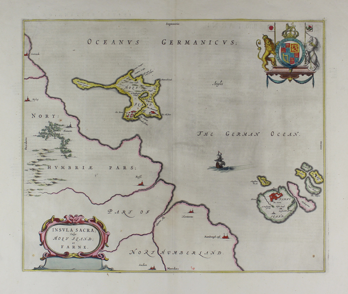
A large and decorative map of the Holy Island of Lindisfarne and the Farne Islands, off the coast of Northumberland, from the 1645 German edition of the Blaeu Atlas Novus. The islands are shown in relation to the fairly sparsely detailed Northumbrian coast, with the various features of the islands labelled and, in the case of structures, shown pictorially. A sailing ship occupies the space between the islands, and a decorative cartouche in the bottom left encloses the title. In the top right corner of the map, the Royal Arms are shown. The Blaeu family were one of the most famous publishers of maps, globes and atlases during the seventeenth-century. Cartographers, globe makers and booksellers, the Blaeu business flourished in Amsterdam for over 40 years, until a fire destroyed their premises in 1672. They lost all of their plates, prints and stock, which effectively ruined the firm. Willem Janzoon Blaeu (1571-1638) founded the family business in 1596. It initially functioned as a globe and instrument makers, but soon expanded into maps, topography and sea charts. The acquisition of thirty-eight copper plates from the estate of Jodocus Hondius in 162 together with twenty-two of his own maps enabled Blaeu to produce his first atlas, the 'Atlas Appendix' in 1630. The Atlas Novus was Willems great work; a major work which intended to include the most up-to-date maps of the entire world. He issued the first two volumes in 1635, but died in 1638 before the atlas was completed. The running of the business was passed on to his sons Johannes (c.1596-1673) and Cornelius, in addition to the role of the official cartographer of the East India Company. After the death of Cornelius in 1644, Johannes continued the business alone and established his own reputation as a great mapmaker. Johannes completed his father's grand project, culminating in 1658 in the production of the famous 'Atlas Major', regarded as one of the greatest achievements in the history of cartography. The county maps of England and Wales formed volume four of Blaeu's great atlas, this volume being first published in 1645 and re-issued without any alterations in 1662 as the fifth volume instead of the fourth. Condition: Central vertical fold, as issued. Clean impression with wide margins. Minor time toning to edges of sheet, not affecting map. German text on verso. |
| Framing | unmounted |
| Price | £280.00 |
| Stock ID | 49086 |