
| Method | Copper engraved |
| Artist | Hondius, Jodocus the Younger |
| Published | [Amsterdam, c.1616] |
| Dimensions | 95 x 135 mm |
| Notes |
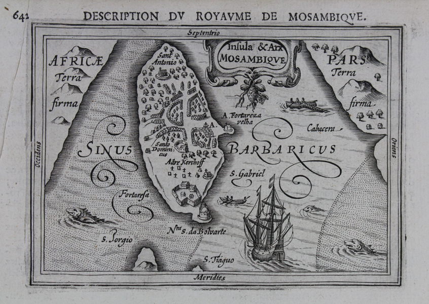
A miniature map of the Ilha de Moçambique, a tiny island off the coast of the modern nation of Mozambique, from a French edition of Petrus Bertius' Tabularum geographicarum contractarum. The map is shown with south to top, with the various colonial buildings and forts of the Portuguese colonial era labelled. Despite its diminutive size, the island was the capital of Portuguese East Africa until 1898. It is now a UNESCO world heritage site. The Chapel of Nossa Senhora de Baluarte, included on the map, is believed to be the oldest surviving European building in the Southern Hemisphere. The map is further embellished by illustrations of various sea craft and sea monsters, as well as a strapwork cartouche at top. The majority of the plates for Petrus Bertius' Tabularum geographicarum contractarum libri septem were reduced versions of those published in the Mercator-Hondius Atlas Minor. The first edition, published by Cornelis Claes, was published in Amsterdam in 1600, using a suite of miniature maps first published in the Caert-Thresoor by Barent Langenes. Over the next fifty years, the Bertius atlas was issued numerous times in Latin, French, and German, its collection of maps continually increasing with new plates, the majority of which were engraved by Bertius' brothers-in-law Jodocus Hondius and van den Keere. Hondius the Younger's first issue of the Bertius atlas, published in 1616, was an immediate commercial success, and the second edition appeared later the same year. Petrus Bertius (14th November 1565 – 13th October 1629) was a Flemish theologian, historian, geographer and cartographer and was related to Jodocus Hondius Sr. and Pieter van den Keere by marriage. Bertius studied at the University of Leiden and later traveled in Germany and Russia. In 1620 he emigrated to France where he was appointed as a cosmographer to the court Louis XIII. Bertius published a number of folio maps, but never published an atlas of his own. His maps were either separately published or included in atlases and books by other publishers. Condition: Binders holes and creasing to right margin. Large printers crease to left margin, not affecting plate. French text on verso. |
| Framing | mounted |
| Price | £120.00 |
| Stock ID | 47332 |