
| Method | Copper engraved |
| Artist | Porro, Girolamo after Porcacchi, Tommaso |
| Published | [In Venetia, MDCIIII. Appresso gli heredi di Simon Galignani. 1604] |
| Dimensions | 101 x 140 mm |
| Notes |
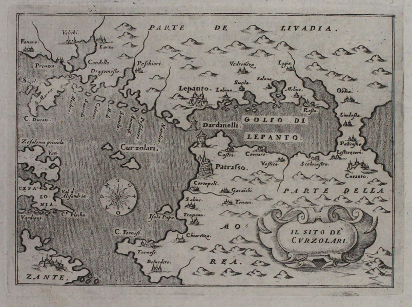
A map of the Echinades, known in Italian as the Curzolari islands, engraved by Girolamo Porro for Tommaso Porcacchi's L'isole più famose del mondo. Although purportedly showing the location of the Curzolari islands, the map's scope, showing the full breadth of the Ionian islands and the Gulf of Corinth, suggests it was essentially engraved to allow Porcacchi to include a description of the famous Battle of Lepanto in 1571, in which the Ottoman navy suffered a serious defeat at the hands of the Holy League, spearheaded by the joint navies of the Venetian Republic and the Spanish Empire. Lepanto, modern day Nafpaktos, was a major naval bastion of the Ottoman fleet, and its suppression drastically reduced Ottoman activity in the Adriatic and Ionian Seas. The cities of Lepanto and Patras are both shown pictorially, as are Corinth, a number of smaller coastal towns, and Zante, modern day Zakynthos. The map's title is enclosed in a strapwork cartouche, and a simple compass is included in the waters between the Peloponnesian peninsula and the island of Cephalonia. Inscription above print: 'Descrittione Dell'Isola, o Scogli Curzolari'. Girolamo Porro (c. 1520-1604) was an Italian engraver active in Venice and his native Padua, working predominantly as a map engraver for Tommaso Porcacchi, and Girolamo Ruscelli. Tommaso Porcacchi (1530-1585) was an Italian humanist, geographer, translator, and author, chiefly remembered for his atlas, L'isole più famose del mondo descritte da Thomaso Porcacchi da Castiglione arretino e intagliate da Girolamo Porro padouano con l'aggiunta di molte isole. As a young man, he studied in Florence under the patronage of Duke Cosimo I. In 1559, he moved to Venice, translating works from Latin and Greek into Italian, on behalf of publishers including Ludovico Domenichi and Giolito de Ferrari. His treatise on the islands of the world included some of the very earliest maps and plans of the new world, including North America, Mexico, and Temistitan, the Aztec capital of Tenochtitlan. Condition: Italian text above, below, and on verso. Minor creasing to top right of sheet, not affecting map. |
| Framing | unmounted |
| Price | £120.00 |
| Stock ID | 45500 |