
| Method | Copper engraved |
| Artist | van den Keere, Pieter |
| Published | Petrus Kaerius Caelavit [William Humble, London, c.1646] |
| Dimensions | 88 x 125 mm |
| Notes |
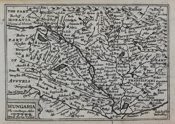
A miniature map of Hungary, engraved by Keere for a companion miniature world atlas to the epitome of John Speed's Theatre. The map also shows parts of Moravia, Austria, Russia, and Transylvania. This example is subtly different from the earlier plate of the same name that Keere originally engraved for Barent Langenes' Caert Thresoor. In around 1642, Keere was commissioned to engrave a further set of twenty miniature maps depicting the continents and the principal nations of the globe for a companion pocket atlas of the world based upon Speed's A Prospect of the Most Famous Parts of the World, inspired by the success of previous editions of the epitome of Speed's county atlas. The first printing of the miniature Prospect was published by William Humble in 1646, the year of Keere's death. Keere's maps of the counties of England and Wales, as well as his regional maps of Scotland and Ireland, were originally begun in 1599, shortly after the engraving of a large number of plates of the rest of the world that appeared originally in Barent Langenes and Cornelis Claesz' Caert-thresoor, and it is likely that the British maps were intended for a British volume of this same series. As it was, the maps were not published until 1617, when Willem Blaeu issued them with Latin text in his Guiliemi Camdeni Britannia in epitomen contracta, a miniature epitome of Camden's celebrated Britannia. By 1619, the plates had passed from Blaeu to George Humble, who retitled them in English and reissued them with English verso text for his miniature edition of Speed's Theatre of Great Britaine and Ireland. Once retitled in English, the plates underwent relatively few revisions. After the publication of England, Wales, and Ireland: the severall counties in 1619, Humble moved his plate numbers from the lower left to the lower right of the plates and reissued the atlas in 1627 under the slightly different title England Wales Scotland and Ireland described, which was retained in subsequent printings by William Humble, Roger Rea, and Bassett & Chiswell. The atlas was a significant commercial success, and as such the maps are often referred to as 'miniature Speeds' by modern collectors, despite the fact that the maps themselves are reductions of the Saxton maps of the counties, and in some instances predate Speed's plates by at least a decade. Pieter van den Keere (1571-c.1646), also known frequently as Petrus Kaerius, came to England in 1584, as a Protestant refugee from his home town of Ghent with his sister Colette, who married Jodocus Hondius in 1587. It was probably from Hondius that Keere learned to engrave. Both engravers left London in 1593 to settle in Amsterdam. His first set of miniature maps were produced for the Middelburg publisher Cornelis Claesz, for inclusion in Barent Langenes' Caert Thresoor. Keere began to engrave a series of miniature maps in 1599 in preparation for a small atlas of the British Isles. The maps were first published in 1617 by William Blaeu with plate numbers and Latin text. They then passed to George Humble, who published them in 1619 and then again in 1627, by which time they had become known colloquially as 'Miniature Speeds.' John Speed (1552-1629) is the most famous of all English cartographers primarily as a result of The Theatre of the Empire of Great Britaine, the first atlas of the British Isles. The maps from this atlas are the best known and most sought-after of all county maps. The maps were derived mainly from the earlier prototypes of Christopher Saxton and John Norden but with notable improvements including parish "Hundreds" and county boundaries, town plans and embellishments such as the coats of arms of local Earls, Dukes, and the Royal Household. The maps are famed for their borders consisting of local inhabitants in national costume and panoramic vignette views of major cities and towns. An added feature is that regular atlas copies have English text printed on the reverse, giving a charming description of life in the early seventeenth century of the region. The overall effect produced very decorative, attractive and informative maps. For the publication of his prestigious atlas, Speed turned to the most successful London print-sellers of the day, John Sudbury and George Humble. William Camden introduced the leading Flemish engraver, Jodocus Hondius Sr. to John Speed in 1607 because first choice engraver William Rogers had died a few years earlier. Work commenced with the printed proofs being sent back and forth between London and Amsterdam for correction and was finally sent to London in 1611 for publication. The work was an immediate success, with the maps themselves being printed for the next 150 years. Speed was born in 1552 at Farndon, Cheshire. Like his father before him he was a tailor by trade, but around 1582 he moved to London. During his spare time Speed pursued his interests of history and cartography and in 1595 his first map of Canaan was published in the "Biblical Times". This raised his profile and he soon came to the attention of poet and dramatist Sir Fulke Greville a prominent figure in the court of Queen Elizabeth. Greville as Treasurer of the Royal Navy gave Speed an appointment in the Customs Service giving him a steady income and time to pursue cartography. Through his work he became a member of such learned societies as the Society of Antiquaries and associated with the likes of William Camden, Robert Cotton, and William Lambarde. He died in 1629 at the age of seventy-seven. Ex.Col.: László Gróf Condition: Minor insect holes to bottom margin, not affecting map. Minor time toning to margins. English text on verso. |
| Framing | mounted |
| Price | £150.00 |
| Stock ID | 51019 |