
| Method | Chromolithograph |
| Artist | [Anonymous] |
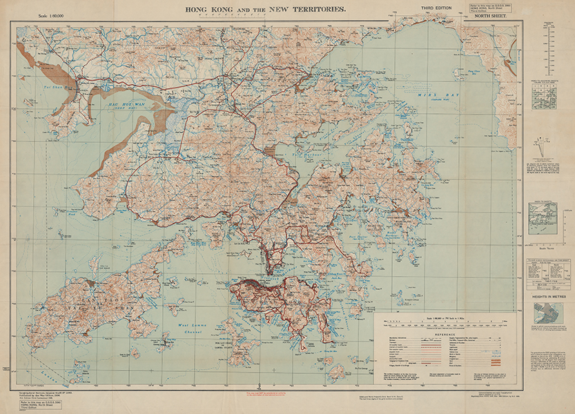
| Published | Published by the War Office, 1936. 3rd Edition (grid Correction) 1946. Reprinted from HIND 1015, Mar 1946 Edition, by O.S. 1949. |
| Dimensions | 635 x 980 mm |
| Notes |
A highly detailed map of Hong Kong, Kowloon, and the New Territories, published during the final stages of the Chinese Civil War. The map is a 1949 reissue of the 3rd edition, compiled by the Geographical Section of the General Staff of the British Army and originally published by the War Office in 1946. The map is incredibly detailed, with individual buildings and houses shown outside of the grid plan of the central districts of Hong Kong and Kowloon. Topographical details, such as elevations, water features, irrigated land, railways, roads, bridges, telegraph and telephone lines, and municipal buildings, are all mapped, corresponding to a large key in the bottom right. The original map 1946 issue of the map followed the reclaiming of Hong Kong by the British in the aftermath of the Japanese surrender in August 1945, and became the standard issue map for the colonial administration of the region. The collapse of the armed forces of the Kuomintang-led Government of the Republic of China and the Proclamation of the People's Republic of China by the victorious Chinese Communist Party in October 1949 created great concern for British interests in Hong Kong. Despite the People's Liberation Army not advancing further than the borders of the New Territories, the period immediately following the Communist victory saw a rapid and exponential increase in population in Hong Kong, both in British military personnel and in refugees from the Chinese mainland. Condition: Horizontal and vertical folds, as issued. Minor staining and time toning to folds and margins. Blank on verso. |
| Framing | unmounted |
| Price | £1,500.00 |
| Stock ID | 53431 |