
| Method | Lithograph with original hand colour |
| Artist | Cartwright, Richard |
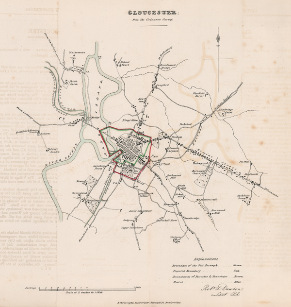
| Published | R. Cartwright, Litho. Printer, Warwick Pl. Bedford Row. [c.1832] |
| Dimensions | 315 x 285 mm |
| Notes |
A map of the City of Gloucester, lithographed by Richard Cartwright for Dawson's 'Plans of the Cities and Boroughs of England and Wales; shewing their boundaries as established by the Boundaries' Act, together with outline maps, shewing the divisions of the counties, the principal places of election, etc.' The two volume work was assembled by Dawson to illustrate the changes made to parliamentary boundaries by the 1832 Great Reform Act, which aimed to eliminate rotten boroughs and better redistribute parliamentary representation in light of the booming population increases and rapid outgrowth of industrial centres. In the case of Gloucester, the suggested changes are minor, simply extending the proposed boundary of the Borough to encompass more land beyond the City's existing southern and eastern boundary. Robert Kearsley Dawson (1798 - 1861) was an English surveyor and cartographer. Born in Dover, Robert was son to Robert Dawson, also a surveyor, and studied at the Royal Military Academy, Woolwich. In 1816 he joined the Royal Engineers, and took part in the triangulation and mapping of Ireland and Scotland under Thomas Colby between 1819 and 1829. In 1831 he was recalled to England to survey the boundaries of the proposed Parliamentary Boroughs for the Great Reform Act, producing a series of 178 city and borough plans. Condition: Vertical folds, as issued. Creases to corners of sheet. Binders holes and creases to right edge of sheet. Light text offsetting. Blank on verso. |
| Framing | unmounted |
| Price | £75.00 |
| Stock ID | 51642 |