
| Method | Copper engraved |
| Artist | Roper, John after Cole, G. |
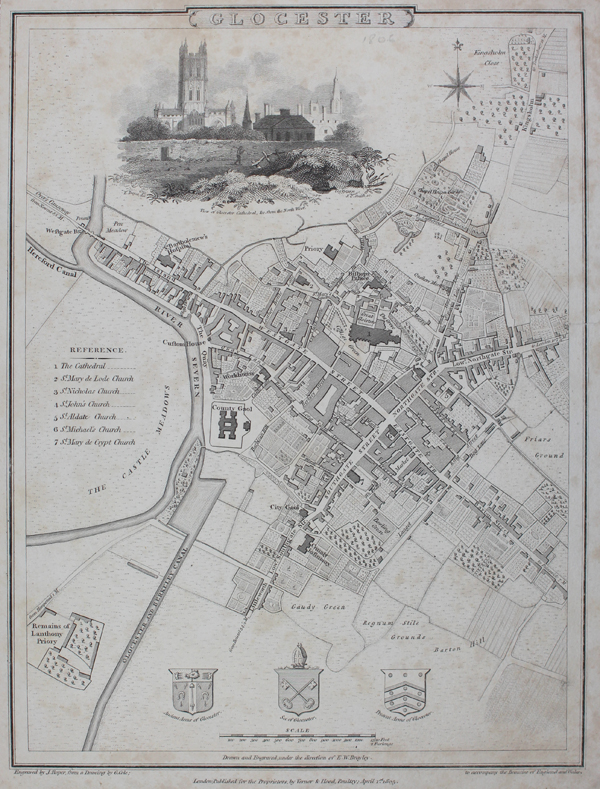
| Published | Engraved by J. Roper, from a Drawing by G. Cole. London, Published for the Proprietors, by Vernor, Hood, & Sharpe, Poultry, April 1st, 1805. |
| Dimensions | 234 x 177 mm |
| Notes |
A detailed map of Gloucester From 'The Beauties of England & Wales'. Including a vignette with a 'View of Gloucester cathedral, &c. from the North West' , the city's coat of arms and a key to the city's churches. John Roper (1771-c.1810) was an English engraver known to have worked from several locations in London. He engraved the maps, drawn by G.Cole, to accompany Edward W. Brayley and John Britton's partwork entitled "Beauties of England Wales". This work was published in 18 volumes between c.1804 and 1810, which was published as "The British Atlas" in 1810 by Verner, Hood and Sharpe. Roper's maps were also re-issued to illustrate the Reverend J Nightingale's "English Topography" of 1816 (and other later editions), published by Baldwin, Craddock and Joy - another publishing partnership of the nineteenth century. Condition: Trimmed within plate mark and laid to a black backing card with hand-drawn silver border. Minor time toning to sheet. Repaired tear to right margin. |
| Framing | unmounted |
| Price | £75.00 |
| Stock ID | 49118 |