
| Method | Copper engraved |
| Artist | Ortelius, Abraham |
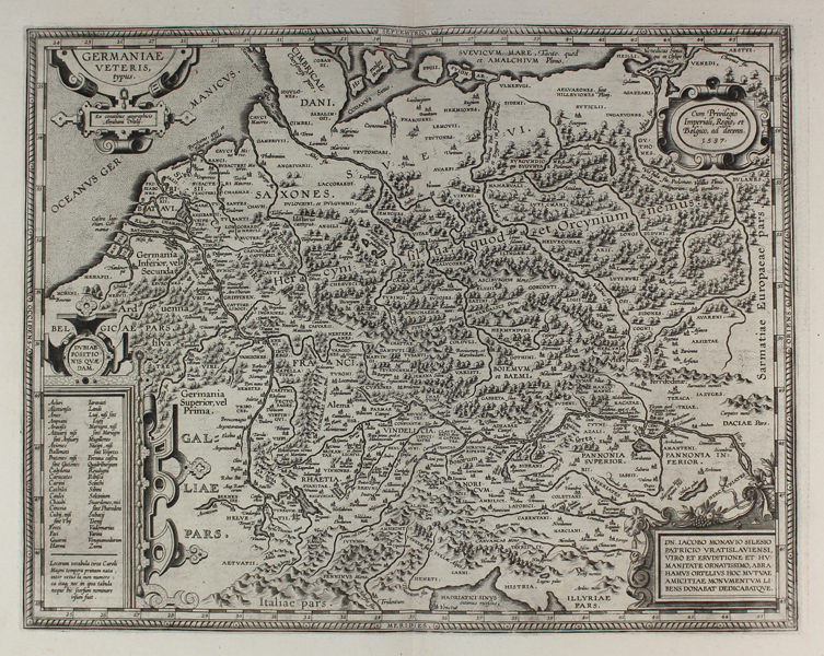
| Published | Cum Privilegio Imperiali, Regio, et Belgico, ad decenn. 1587 [Antwerp, 1595] |
| Dimensions | |
| Notes |
A map of ancient Germania, with particular reference to its tribal divisions during the Roman imperial period, from the 1595 Latin Parergon (Supplement) of Ortelius' famous Theatrum Orbis Terrarum. This is the first printing of Ortelius' second state of this particular map, differing from the first state in only superficial details, such as the inclusion of numbers within the border, rather than without, and the relabelling of Gallia in the bottom left. The map is replete with details of antiquarian interest, with the numerous Germanic tribes and settlements listed. Most of the region is covered by the massive Hercynian forest, a superforest that originally connected the famous forests of Europe, including the Ardenne, the Black Forest, the Jura, the Vosges, and the Teutoburg. In the bottom left corner, a large decorative cartouche contains places of dubious location, while another in the bottom right corner contains a dedication to Jacob Monavus, a Silesian noble. The extensive verso text largely mirrors a pamphlet Ortelius published in 1596 called Aurei Saeculi Imago, which detailed Germanic history and customs during the Roman era. The Parergon ('Supplement') was, as the title suggests, originally conceived of as a supplement to Ortelius' Theatrum. The work, a massive and intricately researched index of the classical world, was accompanied by a series of ancient world maps. Unlike the maps of the Theatrum, the majority of which were reductions of earlier maps, the maps of the Parergon were researched and drawn by Ortelius himself. The work was a huge commercial success, and the maps themselves set the standard for ancient world maps for the duration of the seventeenth century, being reproduced or reprinted by various publishers after Ortelius' final 1624 printing. His interest in the mapping of the ancient world is manifest. The maps of the Parergon are a veritable mine of textual commentary and classical philology, drawing upon Ptolemy, Strabo, Pliny, and many others. Interestingly, the project seems to have been a labour of love, rather than a mercantile venture. Ortelius himself was fascinated with the ancient world, and a formidable classical scholar in his own right. In addition to his work as a cartographer, he dealt in antiquities, visited and surveyed ancient sites across Europe, published a critical edition of Caesar's Gallic Wars in 1593, and assisted Welser in his studies of the famous Tabula Peutingeriana in 1598, producing an engraved copy of the map that can be found in later editions of the Parergon. Abraham Ortelius (1527 -1598) was a Flemish cartographer, cosmographer, geographer and publisher and a contemporary of Gerard Mercator, with whom he travelled through Italy and France. Although it is Mercator who first used the word "Atlas" as a name for a collection of maps, it is Ortelius who is remembered as the creator of the first modern atlas. Theatrum Orbis Terrarum was the first systematically collated set of maps by different map makers in a uniform format. Three Latin editions as well as a Dutch, French and German edition of Theatrum Orbis Terrarum were published by 1572 and a further 25 editions printed before Ortelius' death in 1598. Several more were subsequently printed until around 1612. Ortelius is said to have been the first person to pose the question of the continents once being a single land mass before separating into their current positions. Condition: Superb crisp dark impression. Central vertical fold as issued. Latin text on verso. |
| Framing | unmounted |
| Price | £475.00 |
| Stock ID | 48876 |