
| Method | Copper engraved with hand colour |
| Artist | Bell, Andrew |
| Published | A. Bell Prin. Wals. Sculptor fecit. [A. Bell & C. MacFarquar, Edinburgh, 1797] |
| Dimensions | 195 x 350 mm |
| Notes |
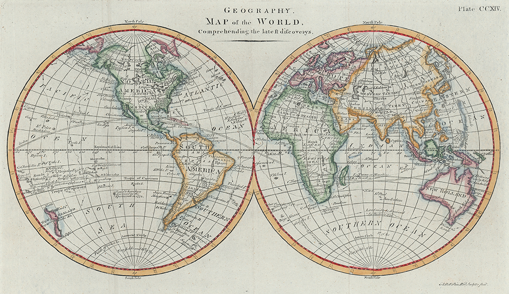
A popular late eighteenth century of the world in twin hemispheres, engraved by Andrew Bell for the 'Geography' section of the Encyclopædia Britannica. True to its title, the map shows the 'latest discoverys' by Cook, with his voyages marked as an arrowed line. The coasts and borders of the continents are outlined in hand colour, and notes about discovery or claims by the Spanish and French are marked beside a number of islands in the Atlantic and Pacific. Although showing the relatively new colony of New South Wales, and other points along the eastern coast of Australia, such as Cape Byron and Botany Bay, Tasmania is shown joined to the mainland. Antarctica is completely absent, though a pair of notes makes mention of 'Fields of broken ice' and 'Firm fields and Mts. of Ice.' Andrew Bell (1726-1809) was a Scottish engraver, printer, and publisher, best known for the numerous copper-engravings he produced for the Encyclopædia Britannica, a work he co-founded with Colin Macfarquhar. Bell was an eccentric, emphasising his small stature by riding the largest horses available to him, as well as obscuring his abnormally large nose with a false one made of papier-mâché. By the 4th edition of the Encyclopædia, Bell had produced over 500 plates on all subjects, including a series of three for the entry on 'midwifery' that so shocked King George III that he ordered them destroyed. Condition: Vertical folds, as issued. Minor surface creasing to sheet. Blank on verso. |
| Framing | unmounted |
| Price | £225.00 |
| Stock ID | 53149 |