
| Method | Copper engraved with hand colour |
| Artist | Ortelius, Abraham |
| Published | Ex Conatibus geographicis Abrahami Ortelij. Cum privilegio Imp. Regis, et Cancellariae Brabantiae, ad decennium. MDXCVIII [1624 Parergon edition] |
| Dimensions | 350 x 478 mm |
| Notes |
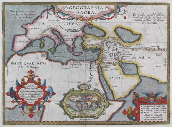
A map of 'Sacred Geography,' essentially depicting the ancient world on a Ptolemaic projection, and showing the lands, peoples, and nations of the Old and New Testament, from the 1624 Parergon (Supplement) of Ortelius' famous Theatrum Orbis Terrarum. The map features the traditional tripartite division of the Old World into the continents of Europa, Asia, and Africa. Africa is here also given the name Phut, a reference to the eponymous Son of Ham that tradition held to have first settled in Libya. As the map draws only upon the text of the Bible for its geographic knowledge, large sections of the map feature only rudimentary details, with some left completely blank. Coasts and borders are outlined in hand colour, and cities and towns are picked out in red. In Europe, the only cities plotted individually are Rome, Athens, Sparta, and Gortina in Crete. Likewise, with the exception of the cities of Egypt, the only African settlement depicted is Tharsis (Carthage). By contrast, the Holy Land is, predictably, very well mapped, with the many cities, towns, and villages of the Bible depicted, many with their Hebrew titles. The map is further embellished by a series of decorative strapwork cartouches, including a large garlanded one enclosing the title, and a box in the bottom right corner featuring a dedication to the Antwerp noble Guilielmus Grimberg. Perhaps the most interesting feature of the map though are the contents of the two cartouches to the bottom and left corner of the plate, describing the source tradition for Ophir, the mythical land of gold. An oval map at centre, essentially a miniature of Ortelius' celebrated map of the World, depicts putative locations of Ophir according to various geographical sources. Ortelius himself believed that, should such a place exist, its most likely location was in southern Africa, perhaps expanding on contemporary theories regarding the location of the Kingdom of Prester John. Others, meanwhile, have suggested sites in the Far East, the Caribbean, and South America, the latter likely a conflation with traveller's stories of Manoa or El Dorado. Cartographically, the map is also of interest for its depiction of the Poles, showing a separate Arctic landmass to the North, titled here using another popular mythographic convention as 'Hyperborea.' This is balanced at the opposite pole by the landmass of Hypernotia, the land 'Beyond the South Wind.' The Parergon ('Supplement') was, as the title suggests, originally conceived of as a supplement to Ortelius' Theatrum. The work, a massive and intricately researched index of the classical world, was accompanied by a series of ancient world maps. Unlike the maps of the Theatrum, the majority of which were reductions of earlier maps, the maps of the Parergon were researched and drawn by Ortelius himself. The work was a huge commercial success, and the maps themselves set the standard for ancient world maps for the duration of the seventeenth century, being reproduced or reprinted by various publishers after Ortelius' final 1624 printing. His interest in the mapping of the ancient world is manifest. The maps of the Parergon are a veritable mine of textual commentary and classical philology, drawing upon Ptolemy, Strabo, Pliny, and many others. Interestingly, the project seems to have been a labour of love, rather than a mercantile venture. Ortelius himself was fascinated with the ancient world, and a formidable classical scholar in his own right. In addition to his work as a cartographer, he dealt in antiquities, visited and surveyed ancient sites across Europe, published a critical edition of Caesar's Gallic Wars in 1593, and assisted Welser in his studies of the famous Tabula Peutingeriana in 1598, producing an engraved copy of the map that can be found in later editions of the Parergon. Abraham Ortelius (1527 -1598) was a Flemish cartographer, cosmographer, geographer and publisher and a contemporary of Gerard Mercator, with whom he travelled through Italy and France. Although it is Mercator who first used the word "Atlas" as a name for a collection of maps, it is Ortelius who is remembered as the creator of the first modern atlas. Theatrum Orbis Terrarum was the first systematically collated set of maps by different map makers in a uniform format. Three Latin editions as well as a Dutch, French and German edition of Theatrum Orbis Terrarum were published by 1572 and a further 25 editions printed before Ortelius' death in 1598. Several more were subsequently printed until around 1612. Ortelius is said to have been the first person to pose the question of the continents once being a single land mass before separating into their current positions. Condition: Clean, dark impression with full margins. Central vertical fold as issued. Minor offsetting to left and right edges of plate. Latin text on verso. |
| Framing | framed |
| Price | £1,000.00 |
| Stock ID | 44508 |